You are here: Home > Network List > UW - Pacific Northwest Regional Seismic Network Stations List
> Station LEBA Lebam, WA, USA > Earthquake Result Viewer
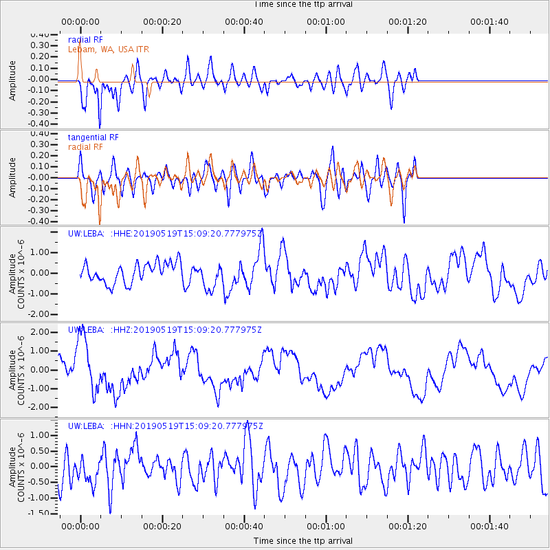
LEBA Lebam, WA, USA - Earthquake Result Viewer
*The percent match for this event was below the threshold and hence no stack was calculated.
| Earthquake location: |
Southeast Of Loyalty Islands |
| Earthquake latitude/longitude: |
-21.6/169.5 |
| Earthquake time(UTC): |
2019/05/19 (139) 14:56:50 GMT |
| Earthquake Depth: |
20 km |
| Earthquake Magnitude: |
6.3 mww |
| Earthquake Catalog/Contributor: |
NEIC PDE/us |
|
| Network: |
UW Pacific Northwest Regional Seismic Network |
| Station: |
LEBA Lebam, WA, USA |
| Lat/Lon: |
46.55 N/123.56 W |
| Elevation: |
73 m |
|
| Distance: |
90.8 deg |
| Az: |
39.438 deg |
| Baz: |
238.922 deg |
| Ray Param: |
$rayparam |
*The percent match for this event was below the threshold and hence was not used in the summary stack. |
|
| Radial Match: |
61.83548 % |
| Radial Bump: |
400 |
| Transverse Match: |
53.446655 % |
| Transverse Bump: |
400 |
| SOD ConfigId: |
18369291 |
| Insert Time: |
2019-06-02 15:02:50.991 +0000 |
| GWidth: |
2.5 |
| Max Bumps: |
400 |
| Tol: |
0.001 |
|
Signal To Noise
| Channel | StoN | STA | LTA |
| UW:LEBA: :HHZ:20190519T15:09:20.777975Z | 2.550078 | 1.5235644E-6 | 5.97458E-7 |
| UW:LEBA: :HHN:20190519T15:09:20.777975Z | 0.70375425 | 4.2094936E-7 | 5.981483E-7 |
| UW:LEBA: :HHE:20190519T15:09:20.777975Z | 1.3386074 | 6.382451E-7 | 4.7679785E-7 |
| Arrivals |
| Ps | |
| PpPs | |
| PsPs/PpSs | |


