You are here: Home > Network List > IW - Intermountain West Stations List
> Station MOOW Moose Ponds, Wyoming, USA > Earthquake Result Viewer
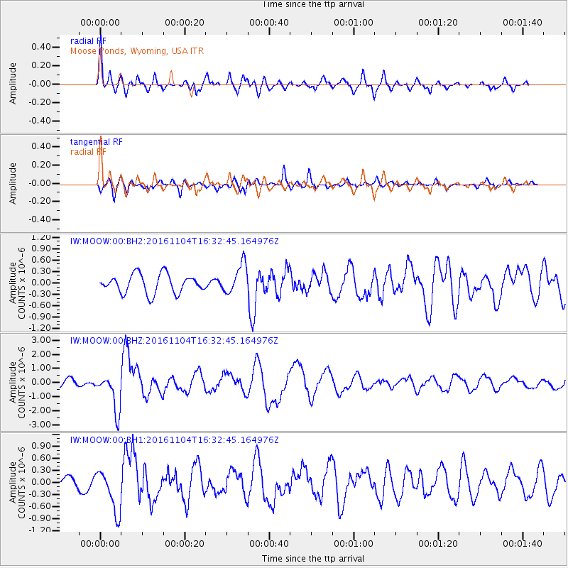
MOOW Moose Ponds, Wyoming, USA - Earthquake Result Viewer
*The percent match for this event was below the threshold and hence no stack was calculated.
| Earthquake location: |
Chile-Argentina Border Region |
| Earthquake latitude/longitude: |
-35.1/-71.0 |
| Earthquake time(UTC): |
2016/11/04 (309) 16:20:43 GMT |
| Earthquake Depth: |
91 km |
| Earthquake Magnitude: |
6.4 MWP, 6.4 MWW |
| Earthquake Catalog/Contributor: |
NEIC PDE/NEIC COMCAT |
|
| Network: |
IW Intermountain West |
| Station: |
MOOW Moose Ponds, Wyoming, USA |
| Lat/Lon: |
43.75 N/110.74 W |
| Elevation: |
2128 m |
|
| Distance: |
86.4 deg |
| Az: |
332.336 deg |
| Baz: |
148.312 deg |
| Ray Param: |
$rayparam |
*The percent match for this event was below the threshold and hence was not used in the summary stack. |
|
| Radial Match: |
79.13538 % |
| Radial Bump: |
400 |
| Transverse Match: |
67.792915 % |
| Transverse Bump: |
302 |
| SOD ConfigId: |
1815711 |
| Insert Time: |
2016-11-18 16:25:41.578 +0000 |
| GWidth: |
2.5 |
| Max Bumps: |
400 |
| Tol: |
0.001 |
|
Signal To Noise
| Channel | StoN | STA | LTA |
| IW:MOOW:00:BHZ:20161104T16:32:45.164976Z | 4.906837 | 1.3830571E-6 | 2.8186327E-7 |
| IW:MOOW:00:BH1:20161104T16:32:45.164976Z | 3.594029 | 5.384225E-7 | 1.4981029E-7 |
| IW:MOOW:00:BH2:20161104T16:32:45.164976Z | 1.6210074 | 4.000311E-7 | 2.467793E-7 |
| Arrivals |
| Ps | |
| PpPs | |
| PsPs/PpSs | |


