You are here: Home > Network List > TA - USArray Transportable Network (new EarthScope stations) Stations List
> Station N21A Black Mountain, Craig, CO, USA > Earthquake Result Viewer
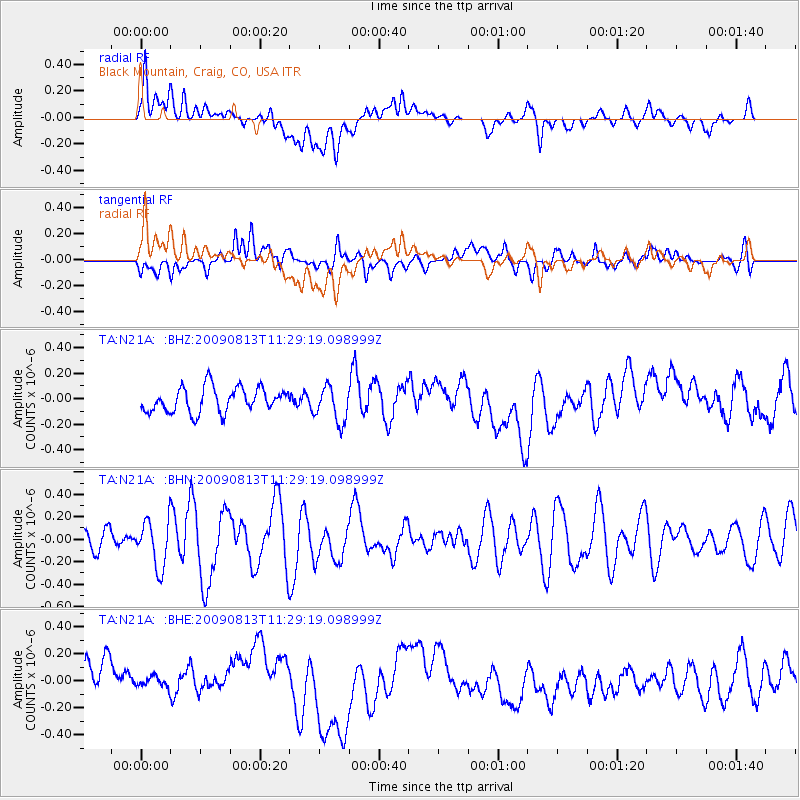
N21A Black Mountain, Craig, CO, USA - Earthquake Result Viewer
*The percent match for this event was below the threshold and hence no stack was calculated.
| Earthquake location: |
Tonga Islands |
| Earthquake latitude/longitude: |
-21.7/-174.6 |
| Earthquake time(UTC): |
2009/08/13 (225) 11:17:01 GMT |
| Earthquake Depth: |
10 km |
| Earthquake Magnitude: |
5.6 MW, 5.3 MB |
| Earthquake Catalog/Contributor: |
WHDF/NEIC |
|
| Network: |
TA USArray Transportable Network (new EarthScope stations) |
| Station: |
N21A Black Mountain, Craig, CO, USA |
| Lat/Lon: |
40.76 N/107.52 W |
| Elevation: |
2235 m |
|
| Distance: |
87.9 deg |
| Az: |
44.422 deg |
| Baz: |
238.998 deg |
| Ray Param: |
$rayparam |
*The percent match for this event was below the threshold and hence was not used in the summary stack. |
|
| Radial Match: |
44.316116 % |
| Radial Bump: |
400 |
| Transverse Match: |
30.002047 % |
| Transverse Bump: |
400 |
| SOD ConfigId: |
2622 |
| Insert Time: |
2010-03-06 22:46:20.945 +0000 |
| GWidth: |
2.5 |
| Max Bumps: |
400 |
| Tol: |
0.001 |
|
Signal To Noise
| Channel | StoN | STA | LTA |
| TA:N21A: :BHN:20090813T11:29:19.098999Z | 2.286498 | 2.095317E-7 | 9.1638704E-8 |
| TA:N21A: :BHE:20090813T11:29:19.098999Z | 0.52055824 | 8.703992E-8 | 1.6720496E-7 |
| TA:N21A: :BHZ:20090813T11:29:19.098999Z | 1.4507005 | 1.408843E-7 | 9.711466E-8 |
| Arrivals |
| Ps | |
| PpPs | |
| PsPs/PpSs | |


