You are here: Home > Network List > TA - USArray Transportable Network (new EarthScope stations) Stations List
> Station N21A Black Mountain, Craig, CO, USA > Earthquake Result Viewer
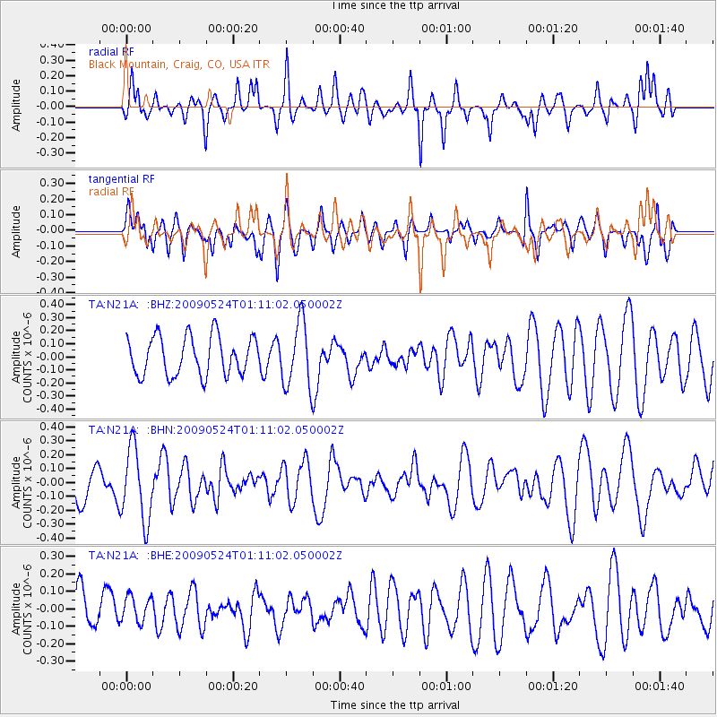
N21A Black Mountain, Craig, CO, USA - Earthquake Result Viewer
*The percent match for this event was below the threshold and hence no stack was calculated.
| Earthquake location: |
Kermadec Islands Region |
| Earthquake latitude/longitude: |
-31.5/-177.7 |
| Earthquake time(UTC): |
2009/05/24 (144) 00:58:02 GMT |
| Earthquake Depth: |
4.0 km |
| Earthquake Magnitude: |
5.6 MB, 5.9 MS, 6.0 MW, 5.8 MW |
| Earthquake Catalog/Contributor: |
WHDF/NEIC |
|
| Network: |
TA USArray Transportable Network (new EarthScope stations) |
| Station: |
N21A Black Mountain, Craig, CO, USA |
| Lat/Lon: |
40.76 N/107.52 W |
| Elevation: |
2235 m |
|
| Distance: |
96.8 deg |
| Az: |
46.017 deg |
| Baz: |
234.032 deg |
| Ray Param: |
$rayparam |
*The percent match for this event was below the threshold and hence was not used in the summary stack. |
|
| Radial Match: |
52.634617 % |
| Radial Bump: |
400 |
| Transverse Match: |
55.168217 % |
| Transverse Bump: |
400 |
| SOD ConfigId: |
2648 |
| Insert Time: |
2010-03-06 22:46:31.749 +0000 |
| GWidth: |
2.5 |
| Max Bumps: |
400 |
| Tol: |
0.001 |
|
Signal To Noise
| Channel | StoN | STA | LTA |
| TA:N21A: :BHN:20090524T01:11:02.050002Z | 1.918414 | 2.640397E-7 | 1.3763436E-7 |
| TA:N21A: :BHE:20090524T01:11:02.050002Z | 0.447995 | 7.619079E-8 | 1.700706E-7 |
| TA:N21A: :BHZ:20090524T01:11:02.050002Z | 1.7065008 | 2.5380754E-7 | 1.4872981E-7 |
| Arrivals |
| Ps | |
| PpPs | |
| PsPs/PpSs | |


