You are here: Home > Network List > TA - USArray Transportable Network (new EarthScope stations) Stations List
> Station B18K Kokolik River, AK, USA > Earthquake Result Viewer
B18K Kokolik River, AK, USA - Earthquake Result Viewer
| Earthquake location: |
Andaman Islands, India Region |
| Earthquake latitude/longitude: |
13.9/92.9 |
| Earthquake time(UTC): |
2019/05/22 (142) 00:39:32 GMT |
| Earthquake Depth: |
10 km |
| Earthquake Magnitude: |
5.6 Mww |
| Earthquake Catalog/Contributor: |
NEIC PDE/us |
|
| Network: |
TA USArray Transportable Network (new EarthScope stations) |
| Station: |
B18K Kokolik River, AK, USA |
| Lat/Lon: |
69.36 N/161.80 W |
| Elevation: |
222 m |
|
| Distance: |
82.4 deg |
| Az: |
20.185 deg |
| Baz: |
289.044 deg |
| Ray Param: |
0.046919603 |
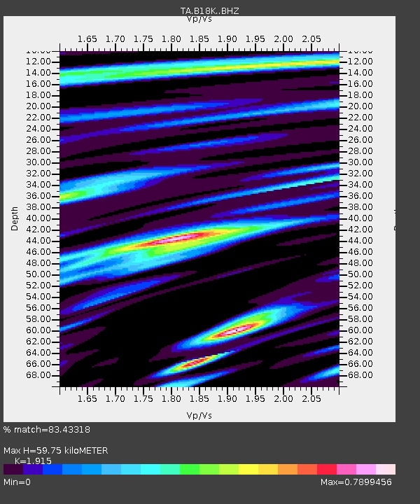
| Estimated Moho Depth: |
59.75 km |
| Estimated Crust Vp/Vs: |
1.91 |
| Assumed Crust Vp: |
5.906 km/s |
| Estimated Crust Vs: |
3.084 km/s |
| Estimated Crust Poisson's Ratio: |
0.31 |
|
| Radial Match: |
83.43318 % |
| Radial Bump: |
400 |
| Transverse Match: |
76.55998 % |
| Transverse Bump: |
400 |
| SOD ConfigId: |
18369291 |
| Insert Time: |
2019-06-05 00:43:31.636 +0000 |
| GWidth: |
2.5 |
| Max Bumps: |
400 |
| Tol: |
0.001 |
|
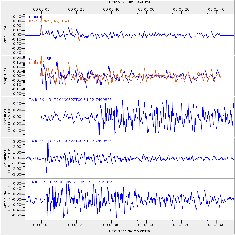
Signal To Noise
| Channel | StoN | STA | LTA |
| TA:B18K: :BHZ:20190522T00:51:22.749988Z | 11.947167 | 1.2338816E-6 | 1.0327817E-7 |
| TA:B18K: :BHN:20190522T00:51:22.749988Z | 2.1845267 | 2.2520508E-7 | 1.03091025E-7 |
| TA:B18K: :BHE:20190522T00:51:22.749988Z | 2.388702 | 1.8204284E-7 | 7.620994E-8 |
| Arrivals |
| Ps | 9.4 SECOND |
| PpPs | 29 SECOND |
| PsPs/PpSs | 38 SECOND |


