You are here: Home > Network List > TA - USArray Transportable Network (new EarthScope stations) Stations List
> Station N21A Black Mountain, Craig, CO, USA > Earthquake Result Viewer
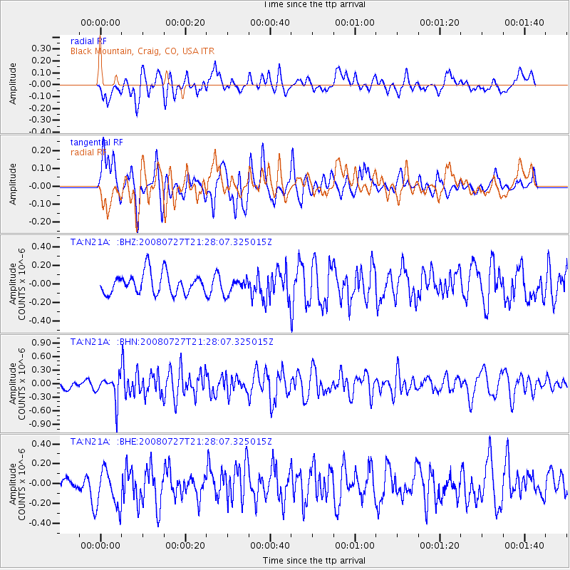
N21A Black Mountain, Craig, CO, USA - Earthquake Result Viewer
*The percent match for this event was below the threshold and hence no stack was calculated.
| Earthquake location: |
Central Mid-Atlantic Ridge |
| Earthquake latitude/longitude: |
-0.3/-18.3 |
| Earthquake time(UTC): |
2008/07/27 (209) 21:15:41 GMT |
| Earthquake Depth: |
10 km |
| Earthquake Magnitude: |
5.8 MB, 5.3 MS, 5.9 MW, 5.8 MW |
| Earthquake Catalog/Contributor: |
WHDF/NEIC |
|
| Network: |
TA USArray Transportable Network (new EarthScope stations) |
| Station: |
N21A Black Mountain, Craig, CO, USA |
| Lat/Lon: |
40.76 N/107.52 W |
| Elevation: |
2235 m |
|
| Distance: |
89.6 deg |
| Az: |
310.574 deg |
| Baz: |
90.7 deg |
| Ray Param: |
$rayparam |
*The percent match for this event was below the threshold and hence was not used in the summary stack. |
|
| Radial Match: |
53.461887 % |
| Radial Bump: |
400 |
| Transverse Match: |
56.09844 % |
| Transverse Bump: |
400 |
| SOD ConfigId: |
2504 |
| Insert Time: |
2010-03-06 22:47:22.086 +0000 |
| GWidth: |
2.5 |
| Max Bumps: |
400 |
| Tol: |
0.001 |
|
Signal To Noise
| Channel | StoN | STA | LTA |
| TA:N21A: :BHN:20080727T21:28:07.325015Z | 3.085771 | 2.8059426E-7 | 9.093165E-8 |
| TA:N21A: :BHE:20080727T21:28:07.325015Z | 2.4878378 | 2.0530368E-7 | 8.252294E-8 |
| TA:N21A: :BHZ:20080727T21:28:07.325015Z | 0.734946 | 8.141256E-8 | 1.1077353E-7 |
| Arrivals |
| Ps | |
| PpPs | |
| PsPs/PpSs | |


