You are here: Home > Network List > TA - USArray Transportable Network (new EarthScope stations) Stations List
> Station D22K Ayikyak River, AK, USA > Earthquake Result Viewer
D22K Ayikyak River, AK, USA - Earthquake Result Viewer
| Earthquake location: |
Andaman Islands, India Region |
| Earthquake latitude/longitude: |
13.9/92.9 |
| Earthquake time(UTC): |
2019/05/22 (142) 00:39:32 GMT |
| Earthquake Depth: |
10 km |
| Earthquake Magnitude: |
5.6 Mww |
| Earthquake Catalog/Contributor: |
NEIC PDE/us |
|
| Network: |
TA USArray Transportable Network (new EarthScope stations) |
| Station: |
D22K Ayikyak River, AK, USA |
| Lat/Lon: |
68.88 N/152.68 W |
| Elevation: |
532 m |
|
| Distance: |
85.6 deg |
| Az: |
19.337 deg |
| Baz: |
297.47 deg |
| Ray Param: |
0.044659834 |
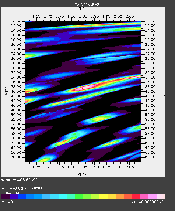
| Estimated Moho Depth: |
38.5 km |
| Estimated Crust Vp/Vs: |
1.85 |
| Assumed Crust Vp: |
6.221 km/s |
| Estimated Crust Vs: |
3.372 km/s |
| Estimated Crust Poisson's Ratio: |
0.29 |
|
| Radial Match: |
86.62693 % |
| Radial Bump: |
400 |
| Transverse Match: |
82.36003 % |
| Transverse Bump: |
400 |
| SOD ConfigId: |
18369291 |
| Insert Time: |
2019-06-05 00:43:41.268 +0000 |
| GWidth: |
2.5 |
| Max Bumps: |
400 |
| Tol: |
0.001 |
|

Signal To Noise
| Channel | StoN | STA | LTA |
| TA:D22K: :BHZ:20190522T00:51:38.975024Z | 6.6736207 | 8.1459126E-7 | 1.2206137E-7 |
| TA:D22K: :BHN:20190522T00:51:38.975024Z | 4.3994308 | 1.8181687E-7 | 4.1327365E-8 |
| TA:D22K: :BHE:20190522T00:51:38.975024Z | 4.4484267 | 2.72208E-7 | 6.119197E-8 |
| Arrivals |
| Ps | 5.3 SECOND |
| PpPs | 17 SECOND |
| PsPs/PpSs | 23 SECOND |


