You are here: Home > Network List > US - United States National Seismic Network Stations List
> Station AMTX Amarillo, Texas, USA > Earthquake Result Viewer
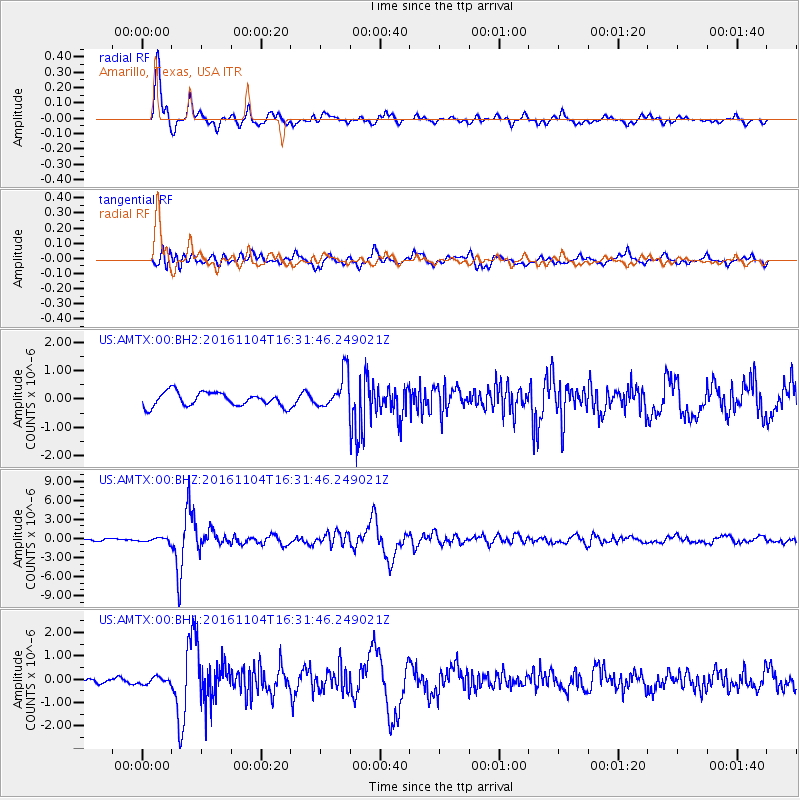
AMTX Amarillo, Texas, USA - Earthquake Result Viewer
*The percent match for this event was below the threshold and hence no stack was calculated.
| Earthquake location: |
Chile-Argentina Border Region |
| Earthquake latitude/longitude: |
-35.1/-71.0 |
| Earthquake time(UTC): |
2016/11/04 (309) 16:20:43 GMT |
| Earthquake Depth: |
91 km |
| Earthquake Magnitude: |
6.4 MWP, 6.4 MWW |
| Earthquake Catalog/Contributor: |
NEIC PDE/NEIC COMCAT |
|
| Network: |
US United States National Seismic Network |
| Station: |
AMTX Amarillo, Texas, USA |
| Lat/Lon: |
34.53 N/101.41 W |
| Elevation: |
1010 m |
|
| Distance: |
74.9 deg |
| Az: |
334.348 deg |
| Baz: |
154.536 deg |
| Ray Param: |
$rayparam |
*The percent match for this event was below the threshold and hence was not used in the summary stack. |
|
| Radial Match: |
94.369446 % |
| Radial Bump: |
400 |
| Transverse Match: |
77.74209 % |
| Transverse Bump: |
400 |
| SOD ConfigId: |
1815711 |
| Insert Time: |
2016-11-18 16:27:31.813 +0000 |
| GWidth: |
2.5 |
| Max Bumps: |
400 |
| Tol: |
0.001 |
|
Signal To Noise
| Channel | StoN | STA | LTA |
| US:AMTX:00:BHZ:20161104T16:31:46.249021Z | 1.4022102 | 3.411094E-7 | 2.432655E-7 |
| US:AMTX:00:BH1:20161104T16:31:46.249021Z | 1.3860551 | 1.4645856E-7 | 1.0566576E-7 |
| US:AMTX:00:BH2:20161104T16:31:46.249021Z | 0.88876235 | 2.0652818E-7 | 2.3237727E-7 |
| Arrivals |
| Ps | |
| PpPs | |
| PsPs/PpSs | |


