You are here: Home > Network List > TA - USArray Transportable Network (new EarthScope stations) Stations List
> Station W14A Seligman, AZ, USA > Earthquake Result Viewer
W14A Seligman, AZ, USA - Earthquake Result Viewer
| Earthquake location: |
Southeast Of Loyalty Islands |
| Earthquake latitude/longitude: |
-21.5/170.9 |
| Earthquake time(UTC): |
2007/07/27 (208) 14:46:26 GMT |
| Earthquake Depth: |
10 km |
| Earthquake Magnitude: |
6.0 MB, 6.0 MS, 6.1 MW, 6.1 MW |
| Earthquake Catalog/Contributor: |
WHDF/NEIC |
|
| Network: |
TA USArray Transportable Network (new EarthScope stations) |
| Station: |
W14A Seligman, AZ, USA |
| Lat/Lon: |
35.21 N/113.08 W |
| Elevation: |
1756 m |
|
| Distance: |
91.4 deg |
| Az: |
52.623 deg |
| Baz: |
244.691 deg |
| Ray Param: |
0.041606672 |
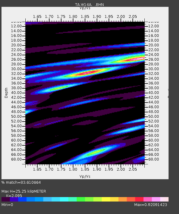
| Estimated Moho Depth: |
25.25 km |
| Estimated Crust Vp/Vs: |
2.10 |
| Assumed Crust Vp: |
6.276 km/s |
| Estimated Crust Vs: |
2.996 km/s |
| Estimated Crust Poisson's Ratio: |
0.35 |
|
| Radial Match: |
83.610664 % |
| Radial Bump: |
388 |
| Transverse Match: |
57.99747 % |
| Transverse Bump: |
400 |
| SOD ConfigId: |
2564 |
| Insert Time: |
2010-03-06 22:47:55.204 +0000 |
| GWidth: |
2.5 |
| Max Bumps: |
400 |
| Tol: |
0.001 |
|
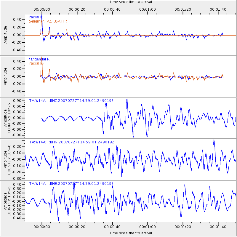
Signal To Noise
| Channel | StoN | STA | LTA |
| TA:W14A: :BHN:20070727T14:59:01.249019Z | 1.0422809 | 6.481602E-8 | 6.2186714E-8 |
| TA:W14A: :BHE:20070727T14:59:01.249019Z | 0.9685294 | 6.0661066E-8 | 6.263213E-8 |
| TA:W14A: :BHZ:20070727T14:59:01.249019Z | 2.1363077 | 1.7781348E-7 | 8.323401E-8 |
| Arrivals |
| Ps | 4.5 SECOND |
| PpPs | 12 SECOND |
| PsPs/PpSs | 17 SECOND |


