You are here: Home > Network List > TA - USArray Transportable Network (new EarthScope stations) Stations List
> Station W14A Seligman, AZ, USA > Earthquake Result Viewer
W14A Seligman, AZ, USA - Earthquake Result Viewer

| Earthquake location: |
Sea Of Japan |
| Earthquake latitude/longitude: |
36.8/134.9 |
| Earthquake time(UTC): |
2007/07/16 (197) 14:17:37 GMT |
| Earthquake Depth: |
350 km |
| Earthquake Magnitude: |
6.2 MB, 6.8 MW, 6.8 MW |
| Earthquake Catalog/Contributor: |
WHDF/NEIC |
|
| Network: |
TA USArray Transportable Network (new EarthScope stations) |
| Station: |
W14A Seligman, AZ, USA |
| Lat/Lon: |
35.21 N/113.08 W |
| Elevation: |
1756 m |
|
| Distance: |
84.5 deg |
| Az: |
49.671 deg |
| Baz: |
311.652 deg |
| Ray Param: |
0.044510487 |
| Estimated Moho Depth: |
31.25 km |
| Estimated Crust Vp/Vs: |
1.88 |
| Assumed Crust Vp: |
6.276 km/s |
| Estimated Crust Vs: |
3.338 km/s |
| Estimated Crust Poisson's Ratio: |
0.30 |
|
| Radial Match: |
93.188675 % |
| Radial Bump: |
400 |
| Transverse Match: |
68.506065 % |
| Transverse Bump: |
400 |
| SOD ConfigId: |
2564 |
| Insert Time: |
2010-03-06 22:47:57.749 +0000 |
| GWidth: |
2.5 |
| Max Bumps: |
400 |
| Tol: |
0.001 |
|
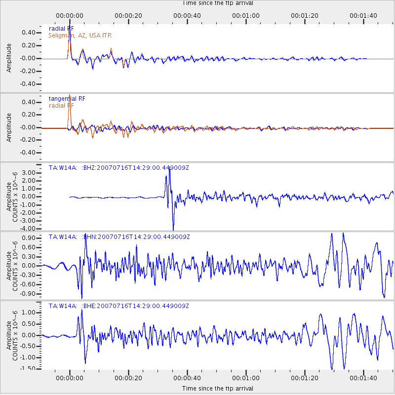
Signal To Noise
| Channel | StoN | STA | LTA |
| TA:W14A: :BHN:20070716T14:29:00.449009Z | 12.304962 | 3.2911626E-7 | 2.6746628E-8 |
| TA:W14A: :BHE:20070716T14:29:00.449009Z | 12.785076 | 3.9374905E-7 | 3.079755E-8 |
| TA:W14A: :BHZ:20070716T14:29:00.449009Z | 26.564522 | 1.2263832E-6 | 4.6166207E-8 |
| Arrivals |
| Ps | 4.5 SECOND |
| PpPs | 14 SECOND |
| PsPs/PpSs | 19 SECOND |


