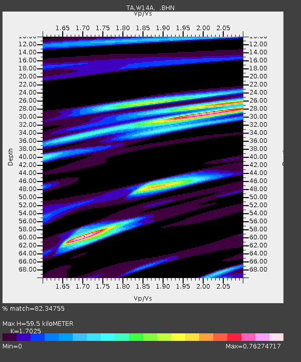
W14A Seligman, AZ, USA - Earthquake Result Viewer

Earthquake location: Near West Coast Of Honshu, Japan
Earthquake latitude/longitude: 37.5/138.5
Earthquake time(UTC): 2007/07/16 (197) 06:37:40 GMT
Earthquake Depth: 15 km
Earthquake Magnitude: 5.7 MB, 5.1 MS, 5.7 MW, 5.6 MW
Earthquake Catalog/Contributor: WHDF/NEIC
Network: TA USArray Transportable Network (new EarthScope stations)
Station: W14A Seligman, AZ, USA
Lat/Lon: 35.21 N/113.08 W
Elevation: 1756 m
Distance: 81.8 deg
Az: 51.692 deg
Baz: 310.347 deg
Ray Param: 0.047293022
Estimated Moho Depth: 59.5 km
Estimated Crust Vp/Vs: 1.70
Assumed Crust Vp: 6.276 km/s
Estimated Crust Vs: 3.686 km/s
Estimated Crust Poisson's Ratio: 0.24
Radial Match: 82.34755 %
Radial Bump: 377
Transverse Match: 67.76176 %
Transverse Bump: 400
SOD ConfigId: 2564
Insert Time: 2010-03-06 22:47:59.584 +0000
GWidth: 2.5
Max Bumps: 400
Tol: 0.001

Signal To Noise

ChannelStoNSTALTA
TA:W14A: :BHN:20070716T06:49:27.398018Z2.5033131.0209453E-74.0783764E-8
TA:W14A: :BHE:20070716T06:49:27.398018Z4.60683061.2491067E-72.711423E-8
TA:W14A: :BHZ:20070716T06:49:27.398018Z5.82189373.4074608E-75.8528396E-8
Arrivals
Ps6.8 SECOND
PpPs25 SECOND
PsPs/PpSs32 SECOND