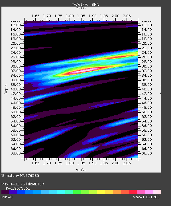
W14A Seligman, AZ, USA - Earthquake Result Viewer

Earthquake location: Near West Coast Of Honshu, Japan
Earthquake latitude/longitude: 37.5/138.4
Earthquake time(UTC): 2007/07/16 (197) 01:13:22 GMT
Earthquake Depth: 12 km
Earthquake Magnitude: 6.5 MB, 6.4 MS, 6.6 MW, 6.5 MW
Earthquake Catalog/Contributor: WHDF/NEIC
Network: TA USArray Transportable Network (new EarthScope stations)
Station: W14A Seligman, AZ, USA
Lat/Lon: 35.21 N/113.08 W
Elevation: 1756 m
Distance: 81.8 deg
Az: 51.684 deg
Baz: 310.384 deg
Ray Param: 0.04730378
Estimated Moho Depth: 31.75 km
Estimated Crust Vp/Vs: 1.86
Assumed Crust Vp: 6.276 km/s
Estimated Crust Vs: 3.379 km/s
Estimated Crust Poisson's Ratio: 0.30
Radial Match: 97.776535 %
Radial Bump: 306
Transverse Match: 91.732315 %
Transverse Bump: 400
SOD ConfigId: 2564
Insert Time: 2010-03-06 22:48:01.651 +0000
GWidth: 2.5
Max Bumps: 400
Tol: 0.001

Signal To Noise

ChannelStoNSTALTA
TA:W14A: :BHN:20070716T01:25:09.825017Z8.2867154.1042728E-74.9528346E-8
TA:W14A: :BHE:20070716T01:25:09.825017Z18.8180455.844725E-73.105915E-8
TA:W14A: :BHZ:20070716T01:25:09.825017Z34.203371.8403225E-65.38053E-8
Arrivals
Ps4.4 SECOND
PpPs14 SECOND
PsPs/PpSs19 SECOND