You are here: Home > Network List > BE - Belgian Seismic Network Stations List
> Station MEM Membach, Belgium > Earthquake Result Viewer
MEM Membach, Belgium - Earthquake Result Viewer
| Earthquake location: |
Andreanof Islands, Aleutian Is. |
| Earthquake latitude/longitude: |
51.4/-178.3 |
| Earthquake time(UTC): |
2019/05/23 (143) 08:45:18 GMT |
| Earthquake Depth: |
28 km |
| Earthquake Magnitude: |
6.1 Mww |
| Earthquake Catalog/Contributor: |
NEIC PDE/us |
|
| Network: |
BE Belgian Seismic Network |
| Station: |
MEM Membach, Belgium |
| Lat/Lon: |
50.61 N/6.01 E |
| Elevation: |
250 m |
|
| Distance: |
78.3 deg |
| Az: |
357.18 deg |
| Baz: |
2.775 deg |
| Ray Param: |
0.049675044 |
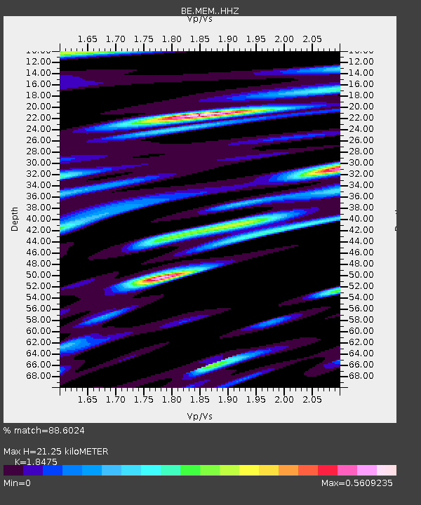
| Estimated Moho Depth: |
21.25 km |
| Estimated Crust Vp/Vs: |
1.85 |
| Assumed Crust Vp: |
6.276 km/s |
| Estimated Crust Vs: |
3.397 km/s |
| Estimated Crust Poisson's Ratio: |
0.29 |
|
| Radial Match: |
88.6024 % |
| Radial Bump: |
400 |
| Transverse Match: |
70.68446 % |
| Transverse Bump: |
400 |
| SOD ConfigId: |
18369291 |
| Insert Time: |
2019-06-06 08:46:06.005 +0000 |
| GWidth: |
2.5 |
| Max Bumps: |
400 |
| Tol: |
0.001 |
|

Signal To Noise
| Channel | StoN | STA | LTA |
| BE:MEM: :HHZ:20190523T08:56:44.997989Z | 16.116385 | 1.4718152E-6 | 9.1324154E-8 |
| BE:MEM: :HHN:20190523T08:56:44.997989Z | 7.551265 | 6.340759E-7 | 8.3969496E-8 |
| BE:MEM: :HHE:20190523T08:56:44.997989Z | 2.0202057 | 1.4933218E-7 | 7.391929E-8 |
| Arrivals |
| Ps | 2.9 SECOND |
| PpPs | 9.4 SECOND |
| PsPs/PpSs | 12 SECOND |


