You are here: Home > Network List > TA - USArray Transportable Network (new EarthScope stations) Stations List
> Station W14A Seligman, AZ, USA > Earthquake Result Viewer
W14A Seligman, AZ, USA - Earthquake Result Viewer
| Earthquake location: |
Jujuy Province, Argentina |
| Earthquake latitude/longitude: |
-22.6/-66.3 |
| Earthquake time(UTC): |
2007/11/18 (322) 05:40:12 GMT |
| Earthquake Depth: |
246 km |
| Earthquake Magnitude: |
5.7 MB, 6.0 MW, 6.0 MW |
| Earthquake Catalog/Contributor: |
WHDF/NEIC |
|
| Network: |
TA USArray Transportable Network (new EarthScope stations) |
| Station: |
W14A Seligman, AZ, USA |
| Lat/Lon: |
35.21 N/113.08 W |
| Elevation: |
1756 m |
|
| Distance: |
72.6 deg |
| Az: |
321.317 deg |
| Baz: |
135.158 deg |
| Ray Param: |
0.052851126 |
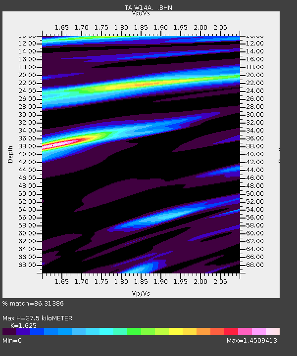
| Estimated Moho Depth: |
37.5 km |
| Estimated Crust Vp/Vs: |
1.62 |
| Assumed Crust Vp: |
6.276 km/s |
| Estimated Crust Vs: |
3.862 km/s |
| Estimated Crust Poisson's Ratio: |
0.20 |
|
| Radial Match: |
86.31386 % |
| Radial Bump: |
400 |
| Transverse Match: |
75.86397 % |
| Transverse Bump: |
400 |
| SOD ConfigId: |
2564 |
| Insert Time: |
2010-03-06 22:48:13.629 +0000 |
| GWidth: |
2.5 |
| Max Bumps: |
400 |
| Tol: |
0.001 |
|
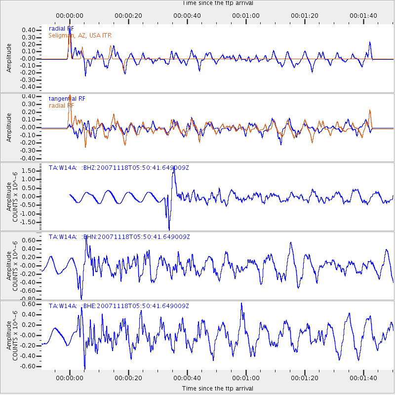
Signal To Noise
| Channel | StoN | STA | LTA |
| TA:W14A: :BHN:20071118T05:50:41.649009Z | 2.6390398 | 3.2154213E-7 | 1.2184059E-7 |
| TA:W14A: :BHE:20071118T05:50:41.649009Z | 0.95838076 | 2.2405064E-7 | 2.337804E-7 |
| TA:W14A: :BHZ:20071118T05:50:41.649009Z | 2.744728 | 6.3466246E-7 | 2.3122962E-7 |
| Arrivals |
| Ps | 3.9 SECOND |
| PpPs | 15 SECOND |
| PsPs/PpSs | 19 SECOND |


