You are here: Home > Network List > TA - USArray Transportable Network (new EarthScope stations) Stations List
> Station W14A Seligman, AZ, USA > Earthquake Result Viewer
W14A Seligman, AZ, USA - Earthquake Result Viewer
| Earthquake location: |
Mariana Islands |
| Earthquake latitude/longitude: |
18.9/145.4 |
| Earthquake time(UTC): |
2007/10/31 (304) 03:30:17 GMT |
| Earthquake Depth: |
223 km |
| Earthquake Magnitude: |
6.2 MB, 7.2 MW, 7.2 MW |
| Earthquake Catalog/Contributor: |
WHDF/NEIC |
|
| Network: |
TA USArray Transportable Network (new EarthScope stations) |
| Station: |
W14A Seligman, AZ, USA |
| Lat/Lon: |
35.21 N/113.08 W |
| Elevation: |
1756 m |
|
| Distance: |
88.3 deg |
| Az: |
53.379 deg |
| Baz: |
291.876 deg |
| Ray Param: |
0.04215812 |
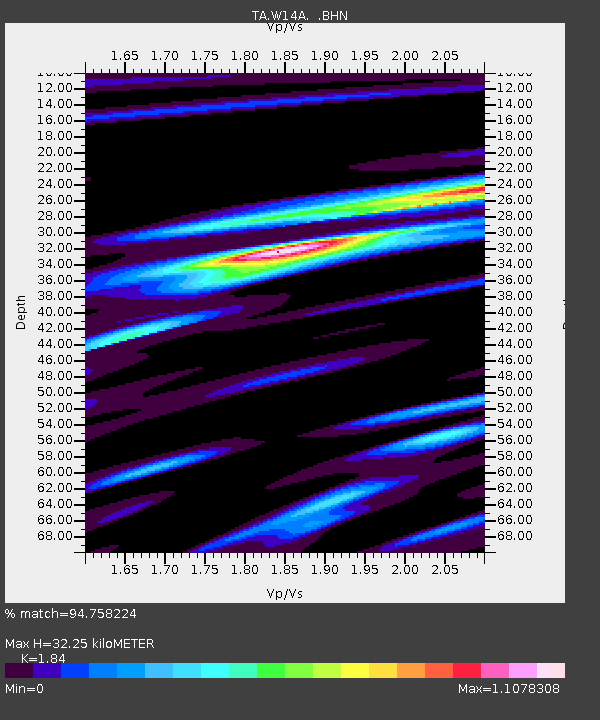
| Estimated Moho Depth: |
32.25 km |
| Estimated Crust Vp/Vs: |
1.84 |
| Assumed Crust Vp: |
6.276 km/s |
| Estimated Crust Vs: |
3.411 km/s |
| Estimated Crust Poisson's Ratio: |
0.29 |
|
| Radial Match: |
94.758224 % |
| Radial Bump: |
314 |
| Transverse Match: |
61.839302 % |
| Transverse Bump: |
400 |
| SOD ConfigId: |
2564 |
| Insert Time: |
2010-03-06 22:48:19.515 +0000 |
| GWidth: |
2.5 |
| Max Bumps: |
400 |
| Tol: |
0.001 |
|

Signal To Noise
| Channel | StoN | STA | LTA |
| TA:W14A: :BHN:20071031T03:42:12.475002Z | 2.6458685 | 3.533483E-7 | 1.3354719E-7 |
| TA:W14A: :BHE:20071031T03:42:12.475002Z | 5.262447 | 1.238949E-6 | 2.3543211E-7 |
| TA:W14A: :BHZ:20071031T03:42:12.475002Z | 19.156635 | 3.188547E-6 | 1.6644609E-7 |
| Arrivals |
| Ps | 4.4 SECOND |
| PpPs | 14 SECOND |
| PsPs/PpSs | 19 SECOND |


