You are here: Home > Network List > TA - USArray Transportable Network (new EarthScope stations) Stations List
> Station W14A Seligman, AZ, USA > Earthquake Result Viewer
W14A Seligman, AZ, USA - Earthquake Result Viewer
| Earthquake location: |
Tonga Islands |
| Earthquake latitude/longitude: |
-17.5/-174.3 |
| Earthquake time(UTC): |
2007/08/26 (238) 12:37:31 GMT |
| Earthquake Depth: |
127 km |
| Earthquake Magnitude: |
5.9 MB, 6.1 MW |
| Earthquake Catalog/Contributor: |
WHDF/NEIC |
|
| Network: |
TA USArray Transportable Network (new EarthScope stations) |
| Station: |
W14A Seligman, AZ, USA |
| Lat/Lon: |
35.21 N/113.08 W |
| Elevation: |
1756 m |
|
| Distance: |
78.2 deg |
| Az: |
47.176 deg |
| Baz: |
238.757 deg |
| Ray Param: |
0.049511623 |
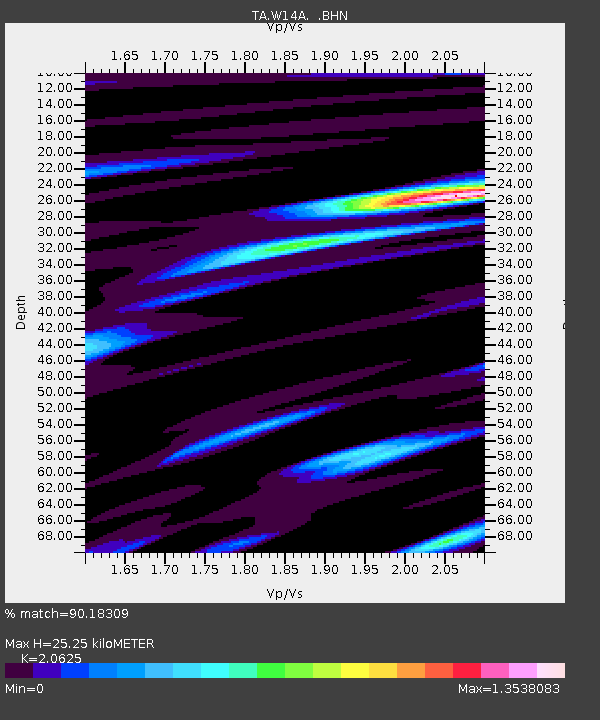
| Estimated Moho Depth: |
25.25 km |
| Estimated Crust Vp/Vs: |
2.06 |
| Assumed Crust Vp: |
6.276 km/s |
| Estimated Crust Vs: |
3.043 km/s |
| Estimated Crust Poisson's Ratio: |
0.35 |
|
| Radial Match: |
90.18309 % |
| Radial Bump: |
314 |
| Transverse Match: |
74.5126 % |
| Transverse Bump: |
378 |
| SOD ConfigId: |
2564 |
| Insert Time: |
2010-03-06 22:48:37.670 +0000 |
| GWidth: |
2.5 |
| Max Bumps: |
400 |
| Tol: |
0.001 |
|

Signal To Noise
| Channel | StoN | STA | LTA |
| TA:W14A: :BHN:20070826T12:48:45.525022Z | 2.7933304 | 2.3383363E-7 | 8.371141E-8 |
| TA:W14A: :BHE:20070826T12:48:45.525022Z | 11.330366 | 4.4873815E-7 | 3.9604913E-8 |
| TA:W14A: :BHZ:20070826T12:48:45.525022Z | 14.138989 | 1.0560901E-6 | 7.469347E-8 |
| Arrivals |
| Ps | 4.4 SECOND |
| PpPs | 12 SECOND |
| PsPs/PpSs | 16 SECOND |


