You are here: Home > Network List > CU - Caribbean Network (USGS) Stations List
> Station MTDJ Mount Denham, Jamaica > Earthquake Result Viewer
MTDJ Mount Denham, Jamaica - Earthquake Result Viewer
| Earthquake location: |
Andreanof Islands, Aleutian Is. |
| Earthquake latitude/longitude: |
51.4/-178.3 |
| Earthquake time(UTC): |
2019/05/23 (143) 08:45:18 GMT |
| Earthquake Depth: |
28 km |
| Earthquake Magnitude: |
6.1 Mww |
| Earthquake Catalog/Contributor: |
NEIC PDE/us |
|
| Network: |
CU Caribbean Network (USGS) |
| Station: |
MTDJ Mount Denham, Jamaica |
| Lat/Lon: |
18.23 N/77.53 W |
| Elevation: |
925 m |
|
| Distance: |
82.5 deg |
| Az: |
70.337 deg |
| Baz: |
321.599 deg |
| Ray Param: |
0.04681303 |
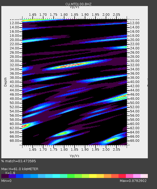
| Estimated Moho Depth: |
61.0 km |
| Estimated Crust Vp/Vs: |
1.60 |
| Assumed Crust Vp: |
4.662 km/s |
| Estimated Crust Vs: |
2.914 km/s |
| Estimated Crust Poisson's Ratio: |
0.18 |
|
| Radial Match: |
83.473595 % |
| Radial Bump: |
400 |
| Transverse Match: |
68.49609 % |
| Transverse Bump: |
400 |
| SOD ConfigId: |
18369291 |
| Insert Time: |
2019-06-06 08:47:53.692 +0000 |
| GWidth: |
2.5 |
| Max Bumps: |
400 |
| Tol: |
0.001 |
|

Signal To Noise
| Channel | StoN | STA | LTA |
| CU:MTDJ:00:BHZ:20190523T08:57:07.249026Z | 8.0645895 | 2.157042E-6 | 2.6747077E-7 |
| CU:MTDJ:00:BH1:20190523T08:57:07.249026Z | 2.2367902 | 5.874268E-7 | 2.6262046E-7 |
| CU:MTDJ:00:BH2:20190523T08:57:07.249026Z | 1.5970385 | 5.3677593E-7 | 3.3610706E-7 |
| Arrivals |
| Ps | 8.0 SECOND |
| PpPs | 34 SECOND |
| PsPs/PpSs | 41 SECOND |


