You are here: Home > Network List > TA - USArray Transportable Network (new EarthScope stations) Stations List
> Station W14A Seligman, AZ, USA > Earthquake Result Viewer
W14A Seligman, AZ, USA - Earthquake Result Viewer
| Earthquake location: |
Sakhalin, Russia |
| Earthquake latitude/longitude: |
47.1/141.8 |
| Earthquake time(UTC): |
2007/08/02 (214) 02:37:42 GMT |
| Earthquake Depth: |
5.0 km |
| Earthquake Magnitude: |
6.2 MS, 5.3 MB, 6.2 MW, 6.2 MW |
| Earthquake Catalog/Contributor: |
WHDF/NEIC |
|
| Network: |
TA USArray Transportable Network (new EarthScope stations) |
| Station: |
W14A Seligman, AZ, USA |
| Lat/Lon: |
35.21 N/113.08 W |
| Elevation: |
1756 m |
|
| Distance: |
74.1 deg |
| Az: |
55.267 deg |
| Baz: |
316.729 deg |
| Ray Param: |
0.05254961 |
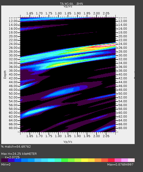
| Estimated Moho Depth: |
24.25 km |
| Estimated Crust Vp/Vs: |
2.07 |
| Assumed Crust Vp: |
6.276 km/s |
| Estimated Crust Vs: |
3.028 km/s |
| Estimated Crust Poisson's Ratio: |
0.35 |
|
| Radial Match: |
84.69762 % |
| Radial Bump: |
378 |
| Transverse Match: |
58.856018 % |
| Transverse Bump: |
400 |
| SOD ConfigId: |
2564 |
| Insert Time: |
2010-03-06 22:48:55.162 +0000 |
| GWidth: |
2.5 |
| Max Bumps: |
400 |
| Tol: |
0.001 |
|
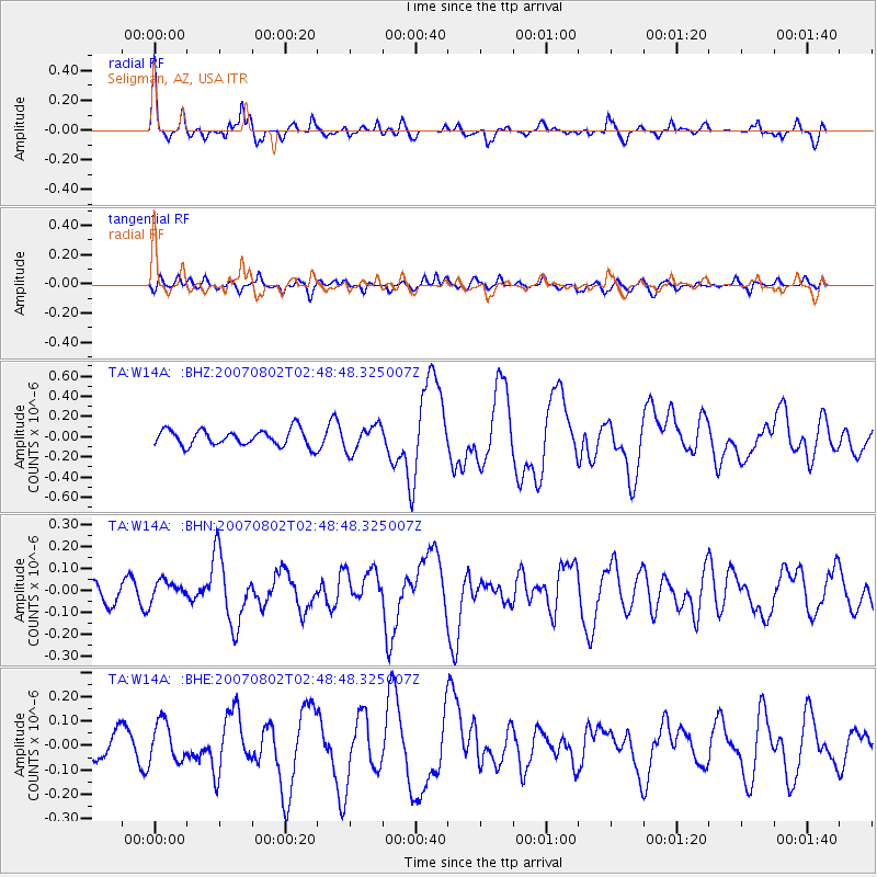
Signal To Noise
| Channel | StoN | STA | LTA |
| TA:W14A: :BHN:20070802T02:48:48.325007Z | 1.0863787 | 4.4904088E-8 | 4.1333735E-8 |
| TA:W14A: :BHE:20070802T02:48:48.325007Z | 1.861911 | 7.97851E-8 | 4.2851187E-8 |
| TA:W14A: :BHZ:20070802T02:48:48.325007Z | 1.6287339 | 1.2973484E-7 | 7.9653795E-8 |
| Arrivals |
| Ps | 4.3 SECOND |
| PpPs | 12 SECOND |
| PsPs/PpSs | 16 SECOND |


