You are here: Home > Network List > TA - USArray Transportable Network (new EarthScope stations) Stations List
> Station W14A Seligman, AZ, USA > Earthquake Result Viewer
W14A Seligman, AZ, USA - Earthquake Result Viewer
| Earthquake location: |
Kuril Islands |
| Earthquake latitude/longitude: |
48.9/154.8 |
| Earthquake time(UTC): |
2007/05/16 (136) 10:17:45 GMT |
| Earthquake Depth: |
10 km |
| Earthquake Magnitude: |
5.5 MB |
| Earthquake Catalog/Contributor: |
WHDF/NEIC |
|
| Network: |
TA USArray Transportable Network (new EarthScope stations) |
| Station: |
W14A Seligman, AZ, USA |
| Lat/Lon: |
35.21 N/113.08 W |
| Elevation: |
1756 m |
|
| Distance: |
65.7 deg |
| Az: |
63.827 deg |
| Baz: |
313.627 deg |
| Ray Param: |
0.05806847 |
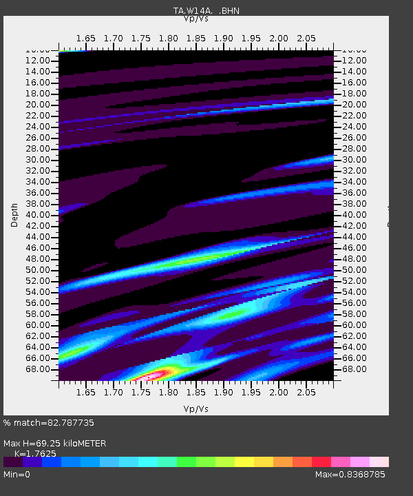
| Estimated Moho Depth: |
69.25 km |
| Estimated Crust Vp/Vs: |
1.76 |
| Assumed Crust Vp: |
6.276 km/s |
| Estimated Crust Vs: |
3.561 km/s |
| Estimated Crust Poisson's Ratio: |
0.26 |
|
| Radial Match: |
82.787735 % |
| Radial Bump: |
280 |
| Transverse Match: |
71.18819 % |
| Transverse Bump: |
320 |
| SOD ConfigId: |
2564 |
| Insert Time: |
2010-03-06 22:49:04.761 +0000 |
| GWidth: |
2.5 |
| Max Bumps: |
400 |
| Tol: |
0.001 |
|
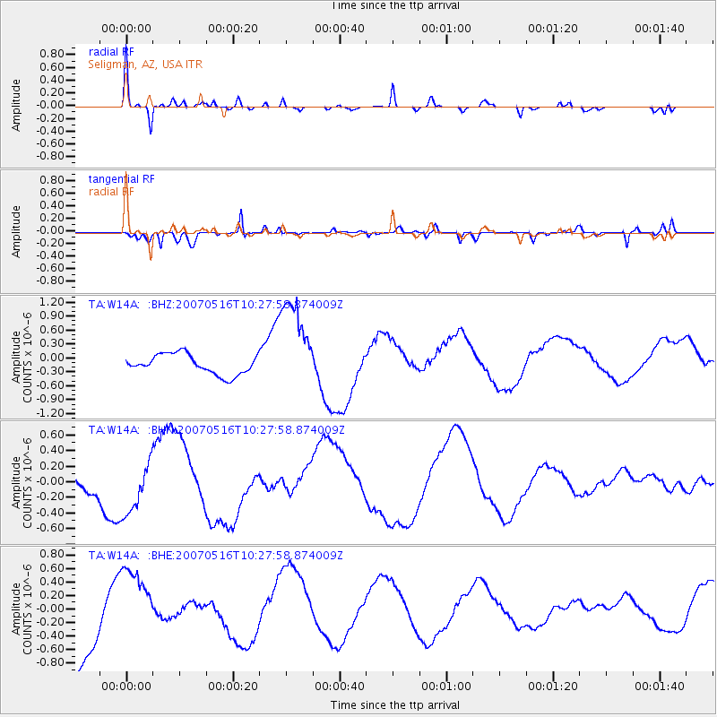
Signal To Noise
| Channel | StoN | STA | LTA |
| TA:W14A: :BHN:20070516T10:27:58.874009Z | 0.88576186 | 3.211925E-7 | 3.626172E-7 |
| TA:W14A: :BHE:20070516T10:27:58.874009Z | 1.1212043 | 5.804038E-7 | 5.176611E-7 |
| TA:W14A: :BHZ:20070516T10:27:58.874009Z | 4.7865744 | 1.0204919E-6 | 2.131988E-7 |
| Arrivals |
| Ps | 8.8 SECOND |
| PpPs | 29 SECOND |
| PsPs/PpSs | 38 SECOND |


