You are here: Home > Network List > GE - GEOFON Stations List
> Station SUMG GEOFON Station Summit Camp, Greenland > Earthquake Result Viewer
SUMG GEOFON Station Summit Camp, Greenland - Earthquake Result Viewer
| Earthquake location: |
Andreanof Islands, Aleutian Is. |
| Earthquake latitude/longitude: |
51.4/-178.3 |
| Earthquake time(UTC): |
2019/05/23 (143) 08:45:18 GMT |
| Earthquake Depth: |
28 km |
| Earthquake Magnitude: |
6.1 Mww |
| Earthquake Catalog/Contributor: |
NEIC PDE/us |
|
| Network: |
GE GEOFON |
| Station: |
SUMG GEOFON Station Summit Camp, Greenland |
| Lat/Lon: |
72.57 N/38.46 W |
| Elevation: |
3200 m |
|
| Distance: |
53.2 deg |
| Az: |
14.028 deg |
| Baz: |
329.71 deg |
| Ray Param: |
0.06618363 |
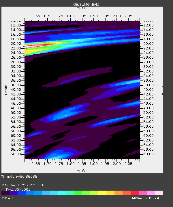
| Estimated Moho Depth: |
21.25 km |
| Estimated Crust Vp/Vs: |
1.61 |
| Assumed Crust Vp: |
6.261 km/s |
| Estimated Crust Vs: |
3.895 km/s |
| Estimated Crust Poisson's Ratio: |
0.18 |
|
| Radial Match: |
86.86086 % |
| Radial Bump: |
400 |
| Transverse Match: |
67.854996 % |
| Transverse Bump: |
400 |
| SOD ConfigId: |
18369291 |
| Insert Time: |
2019-06-06 08:48:35.696 +0000 |
| GWidth: |
2.5 |
| Max Bumps: |
400 |
| Tol: |
0.001 |
|

Signal To Noise
| Channel | StoN | STA | LTA |
| GE:SUMG: :BHZ:20190523T08:54:03.744998Z | 5.74117 | 2.4198273E-6 | 4.214868E-7 |
| GE:SUMG: :BHN:20190523T08:54:03.744998Z | 2.145911 | 7.9154165E-7 | 3.6886047E-7 |
| GE:SUMG: :BHE:20190523T08:54:03.744998Z | 1.9574057 | 4.875188E-7 | 2.4906373E-7 |
| Arrivals |
| Ps | 2.2 SECOND |
| PpPs | 8.4 SECOND |
| PsPs/PpSs | 11 SECOND |


