You are here: Home > Network List > TA - USArray Transportable Network (new EarthScope stations) Stations List
> Station W14A Seligman, AZ, USA > Earthquake Result Viewer
W14A Seligman, AZ, USA - Earthquake Result Viewer
| Earthquake location: |
Solomon Islands |
| Earthquake latitude/longitude: |
-8.5/157.0 |
| Earthquake time(UTC): |
2007/04/01 (091) 20:39:56 GMT |
| Earthquake Depth: |
10 km |
| Earthquake Magnitude: |
6.8 MB, 7.9 MS, 8.1 MW, 7.7 ME |
| Earthquake Catalog/Contributor: |
WHDF/NEIC |
|
| Network: |
TA USArray Transportable Network (new EarthScope stations) |
| Station: |
W14A Seligman, AZ, USA |
| Lat/Lon: |
35.21 N/113.08 W |
| Elevation: |
1756 m |
|
| Distance: |
94.7 deg |
| Az: |
55.246 deg |
| Baz: |
263.03 deg |
| Ray Param: |
0.040975925 |
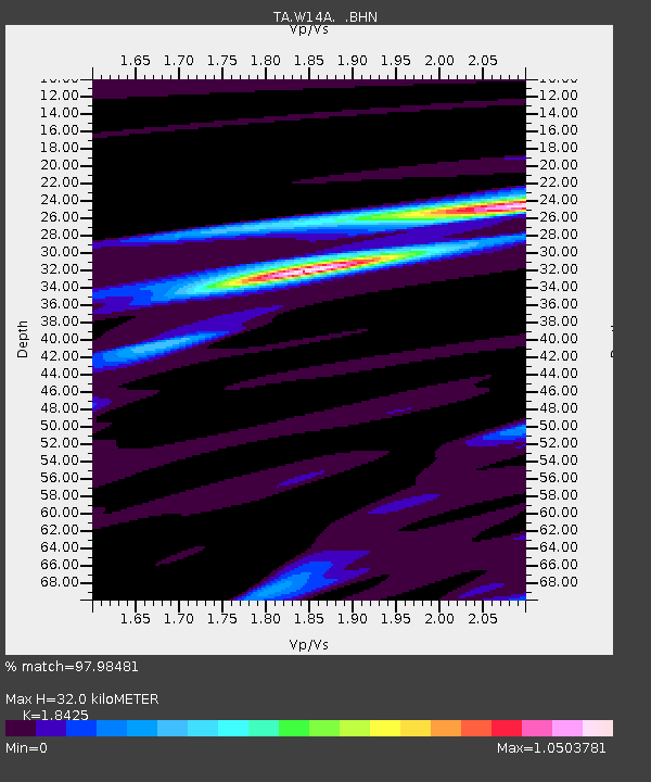
| Estimated Moho Depth: |
32.0 km |
| Estimated Crust Vp/Vs: |
1.84 |
| Assumed Crust Vp: |
6.276 km/s |
| Estimated Crust Vs: |
3.406 km/s |
| Estimated Crust Poisson's Ratio: |
0.29 |
|
| Radial Match: |
97.98481 % |
| Radial Bump: |
262 |
| Transverse Match: |
88.00665 % |
| Transverse Bump: |
400 |
| SOD ConfigId: |
2564 |
| Insert Time: |
2010-03-06 22:49:07.311 +0000 |
| GWidth: |
2.5 |
| Max Bumps: |
400 |
| Tol: |
0.001 |
|

Signal To Noise
| Channel | StoN | STA | LTA |
| TA:W14A: :BHN:20070401T20:52:46.049006Z | 0.58236027 | 4.7574893E-8 | 8.169324E-8 |
| TA:W14A: :BHE:20070401T20:52:46.049006Z | 1.6353502 | 2.0080651E-7 | 1.2279114E-7 |
| TA:W14A: :BHZ:20070401T20:52:46.049006Z | 4.474198 | 6.315347E-7 | 1.4115037E-7 |
| Arrivals |
| Ps | 4.4 SECOND |
| PpPs | 14 SECOND |
| PsPs/PpSs | 19 SECOND |


