You are here: Home > Network List > TA - USArray Transportable Network (new EarthScope stations) Stations List
> Station W14A Seligman, AZ, USA > Earthquake Result Viewer
W14A Seligman, AZ, USA - Earthquake Result Viewer
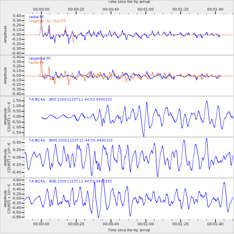
| Earthquake location: |
Tonga Islands |
| Earthquake latitude/longitude: |
-21.3/-174.7 |
| Earthquake time(UTC): |
2006/11/30 (334) 11:33:17 GMT |
| Earthquake Depth: |
14 km |
| Earthquake Magnitude: |
5.7 MB, 6.1 MS, 6.0 MW, 6.0 MW |
| Earthquake Catalog/Contributor: |
WHDF/NEIC |
|
| Network: |
TA USArray Transportable Network (new EarthScope stations) |
| Station: |
W14A Seligman, AZ, USA |
| Lat/Lon: |
35.21 N/113.08 W |
| Elevation: |
1756 m |
|
| Distance: |
81.0 deg |
| Az: |
46.817 deg |
| Baz: |
236.141 deg |
| Ray Param: |
0.04786955 |
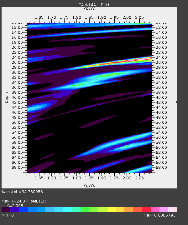
| Estimated Moho Depth: |
24.0 km |
| Estimated Crust Vp/Vs: |
2.10 |
| Assumed Crust Vp: |
6.276 km/s |
| Estimated Crust Vs: |
2.996 km/s |
| Estimated Crust Poisson's Ratio: |
0.35 |
|
| Radial Match: |
84.760056 % |
| Radial Bump: |
398 |
| Transverse Match: |
57.83492 % |
| Transverse Bump: |
329 |
| SOD ConfigId: |
2564 |
| Insert Time: |
2010-03-06 22:49:18.517 +0000 |
| GWidth: |
2.5 |
| Max Bumps: |
400 |
| Tol: |
0.001 |
|
Signal To Noise
| Channel | StoN | STA | LTA |
| TA:W14A: :BHN:20061130T11:44:59.949016Z | 1.237445 | 1.5096239E-7 | 1.2199524E-7 |
| TA:W14A: :BHE:20061130T11:44:59.949016Z | 2.3312697 | 2.3464851E-7 | 1.0065266E-7 |
| TA:W14A: :BHZ:20061130T11:44:59.949016Z | 2.262478 | 3.2641287E-7 | 1.4427228E-7 |
| Arrivals |
| Ps | 4.3 SECOND |
| PpPs | 12 SECOND |
| PsPs/PpSs | 16 SECOND |


