You are here: Home > Network List > TA - USArray Transportable Network (new EarthScope stations) Stations List
> Station W14A Seligman, AZ, USA > Earthquake Result Viewer
W14A Seligman, AZ, USA - Earthquake Result Viewer
| Earthquake location: |
East Of Kuril Islands |
| Earthquake latitude/longitude: |
46.4/154.5 |
| Earthquake time(UTC): |
2006/11/16 (320) 06:20:20 GMT |
| Earthquake Depth: |
9.0 km |
| Earthquake Magnitude: |
6.0 MB, 5.4 MS, 5.9 MW, 5.9 MW |
| Earthquake Catalog/Contributor: |
WHDF/NEIC |
|
| Network: |
TA USArray Transportable Network (new EarthScope stations) |
| Station: |
W14A Seligman, AZ, USA |
| Lat/Lon: |
35.21 N/113.08 W |
| Elevation: |
1756 m |
|
| Distance: |
67.1 deg |
| Az: |
62.67 deg |
| Baz: |
311.289 deg |
| Ray Param: |
0.057208043 |
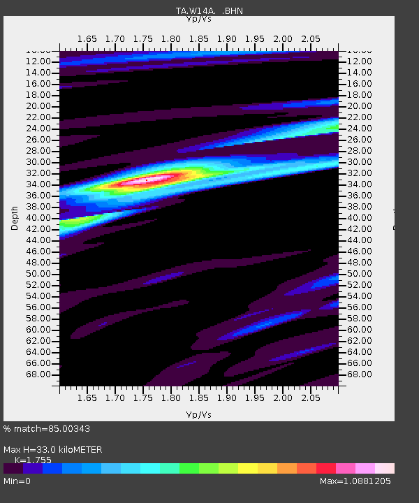
| Estimated Moho Depth: |
33.0 km |
| Estimated Crust Vp/Vs: |
1.75 |
| Assumed Crust Vp: |
6.276 km/s |
| Estimated Crust Vs: |
3.576 km/s |
| Estimated Crust Poisson's Ratio: |
0.26 |
|
| Radial Match: |
85.00343 % |
| Radial Bump: |
400 |
| Transverse Match: |
59.501762 % |
| Transverse Bump: |
400 |
| SOD ConfigId: |
2564 |
| Insert Time: |
2010-03-06 22:49:20.282 +0000 |
| GWidth: |
2.5 |
| Max Bumps: |
400 |
| Tol: |
0.001 |
|

Signal To Noise
| Channel | StoN | STA | LTA |
| TA:W14A: :BHN:20061116T06:30:43.025005Z | 2.3137062 | 2.6880375E-7 | 1.1617887E-7 |
| TA:W14A: :BHE:20061116T06:30:43.025005Z | 1.2696612 | 3.0400722E-7 | 2.3943963E-7 |
| TA:W14A: :BHZ:20061116T06:30:43.025005Z | 3.811258 | 9.307231E-7 | 2.4420365E-7 |
| Arrivals |
| Ps | 4.1 SECOND |
| PpPs | 14 SECOND |
| PsPs/PpSs | 18 SECOND |


