You are here: Home > Network List > TA - USArray Transportable Network (new EarthScope stations) Stations List
> Station W14A Seligman, AZ, USA > Earthquake Result Viewer
W14A Seligman, AZ, USA - Earthquake Result Viewer
| Earthquake location: |
Sakhalin, Russia |
| Earthquake latitude/longitude: |
46.5/141.9 |
| Earthquake time(UTC): |
2006/08/17 (229) 15:20:35 GMT |
| Earthquake Depth: |
17 km |
| Earthquake Magnitude: |
6.0 MB, 5.2 MS, 5.6 MW, 5.5 MW |
| Earthquake Catalog/Contributor: |
WHDF/NEIC |
|
| Network: |
TA USArray Transportable Network (new EarthScope stations) |
| Station: |
W14A Seligman, AZ, USA |
| Lat/Lon: |
35.21 N/113.08 W |
| Elevation: |
1756 m |
|
| Distance: |
74.4 deg |
| Az: |
55.199 deg |
| Baz: |
316.194 deg |
| Ray Param: |
0.052346412 |
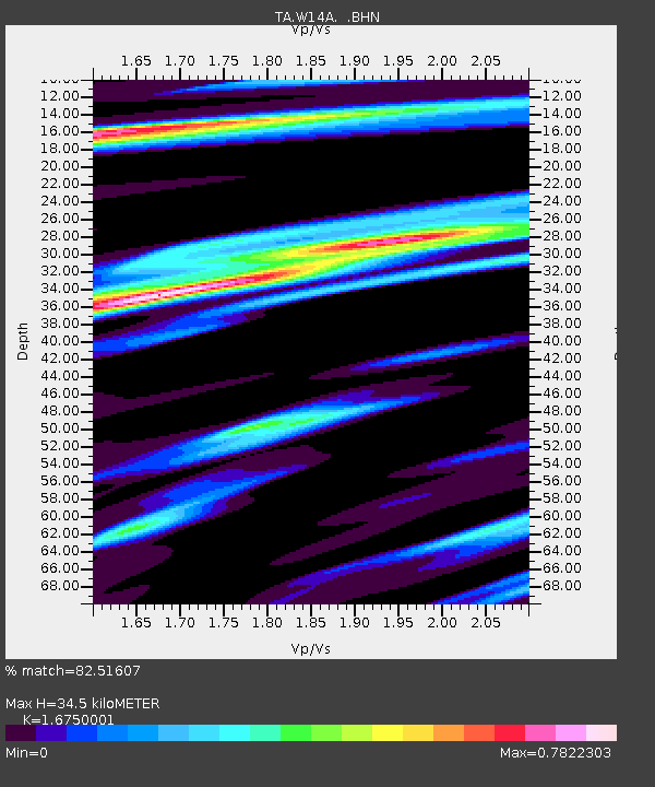
| Estimated Moho Depth: |
34.5 km |
| Estimated Crust Vp/Vs: |
1.68 |
| Assumed Crust Vp: |
6.276 km/s |
| Estimated Crust Vs: |
3.747 km/s |
| Estimated Crust Poisson's Ratio: |
0.22 |
|
| Radial Match: |
82.51607 % |
| Radial Bump: |
400 |
| Transverse Match: |
59.349575 % |
| Transverse Bump: |
360 |
| SOD ConfigId: |
2564 |
| Insert Time: |
2010-03-06 22:49:25.925 +0000 |
| GWidth: |
2.5 |
| Max Bumps: |
400 |
| Tol: |
0.001 |
|
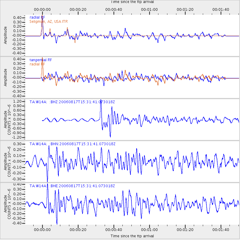
Signal To Noise
| Channel | StoN | STA | LTA |
| TA:W14A: :BHN:20060817T15:31:41.073018Z | 3.8117995 | 1.2831278E-7 | 3.3661994E-8 |
| TA:W14A: :BHE:20060817T15:31:41.073018Z | 3.03105 | 1.3844411E-7 | 4.5675296E-8 |
| TA:W14A: :BHZ:20060817T15:31:41.073018Z | 6.7184296 | 4.471474E-7 | 6.6555344E-8 |
| Arrivals |
| Ps | 3.8 SECOND |
| PpPs | 14 SECOND |
| PsPs/PpSs | 18 SECOND |


