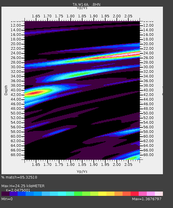
W14A Seligman, AZ, USA - Earthquake Result Viewer
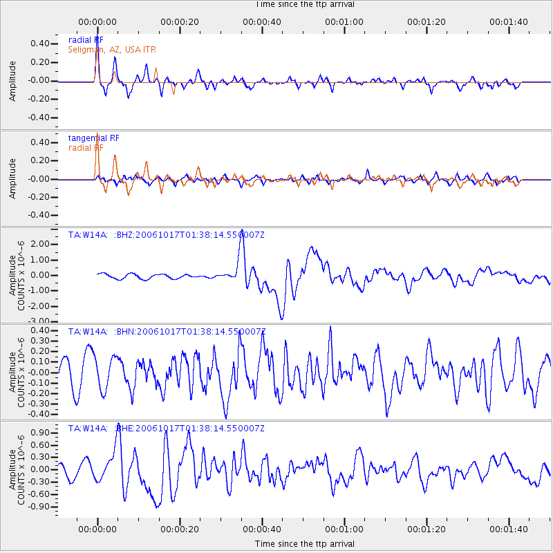
Earthquake location: New Britain Region, P.N.G.
Earthquake latitude/longitude: -5.9/151.0
Earthquake time(UTC): 2006/10/17 (290) 01:25:12 GMT
Earthquake Depth: 32 km
Earthquake Magnitude: 6.4 MB, 6.9 MS, 6.7 MW, 6.6 MW
Earthquake Catalog/Contributor: WHDF/NEIC
Network: TA USArray Transportable Network (new EarthScope stations)
Station: W14A Seligman, AZ, USA
Lat/Lon: 35.21 N/113.08 W
Elevation: 1756 m
Distance: 98.2 deg
Az: 55.372 deg
Baz: 268.593 deg
Ray Param: 0.039960433
Estimated Moho Depth: 24.25 km
Estimated Crust Vp/Vs: 2.05
Assumed Crust Vp: 6.276 km/s
Estimated Crust Vs: 3.065 km/s
Estimated Crust Poisson's Ratio: 0.34
Radial Match: 85.32518 %
Radial Bump: 395
Transverse Match: 56.681183 %
Transverse Bump: 400
SOD ConfigId: 2665
Insert Time: 2010-03-06 22:49:31.329 +0000
GWidth: 2.5
Max Bumps: 400
Tol: 0.001

Signal To Noise

ChannelStoNSTALTA
TA:W14A: :BHN:20061017T01:38:14.550007Z1.38500631.5561378E-71.12356005E-7
TA:W14A: :BHE:20061017T01:38:14.550007Z3.16278653.7822494E-71.1958598E-7
TA:W14A: :BHZ:20061017T01:38:14.550007Z5.10774047.5696664E-71.4819992E-7
Arrivals
Ps4.1 SECOND
PpPs12 SECOND
PsPs/PpSs16 SECOND