You are here: Home > Network List > TA - USArray Transportable Network (new EarthScope stations) Stations List
> Station W14A Seligman, AZ, USA > Earthquake Result Viewer
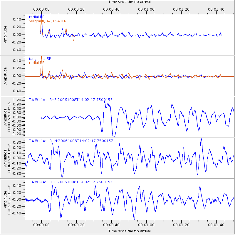
W14A Seligman, AZ, USA - Earthquake Result Viewer

| Earthquake location: |
Tonga Islands Region |
| Earthquake latitude/longitude: |
-23.6/-175.3 |
| Earthquake time(UTC): |
2006/10/08 (281) 13:50:24 GMT |
| Earthquake Depth: |
10 km |
| Earthquake Magnitude: |
5.6 MB, 5.6 MS, 5.8 MW, 5.7 MW |
| Earthquake Catalog/Contributor: |
WHDF/NEIC |
|
| Network: |
TA USArray Transportable Network (new EarthScope stations) |
| Station: |
W14A Seligman, AZ, USA |
| Lat/Lon: |
35.21 N/113.08 W |
| Elevation: |
1756 m |
|
| Distance: |
83.0 deg |
| Az: |
46.865 deg |
| Baz: |
234.866 deg |
| Ray Param: |
0.04652195 |
| Estimated Moho Depth: |
25.0 km |
| Estimated Crust Vp/Vs: |
2.10 |
| Assumed Crust Vp: |
6.276 km/s |
| Estimated Crust Vs: |
2.996 km/s |
| Estimated Crust Poisson's Ratio: |
0.35 |
|
| Radial Match: |
90.41607 % |
| Radial Bump: |
400 |
| Transverse Match: |
76.45557 % |
| Transverse Bump: |
400 |
| SOD ConfigId: |
2665 |
| Insert Time: |
2010-03-06 22:49:37.157 +0000 |
| GWidth: |
2.5 |
| Max Bumps: |
400 |
| Tol: |
0.001 |
|
Signal To Noise
| Channel | StoN | STA | LTA |
| TA:W14A: :BHN:20061008T14:02:17.750015Z | 1.1818763 | 8.236056E-8 | 6.968627E-8 |
| TA:W14A: :BHE:20061008T14:02:17.750015Z | 2.2486515 | 1.2060133E-7 | 5.3632732E-8 |
| TA:W14A: :BHZ:20061008T14:02:17.750015Z | 5.5373106 | 3.8140578E-7 | 6.8879245E-8 |
| Arrivals |
| Ps | 4.5 SECOND |
| PpPs | 12 SECOND |
| PsPs/PpSs | 17 SECOND |


