You are here: Home > Network List > TA - USArray Transportable Network (new EarthScope stations) Stations List
> Station W14A Seligman, AZ, USA > Earthquake Result Viewer
W14A Seligman, AZ, USA - Earthquake Result Viewer
| Earthquake location: |
Trinidad |
| Earthquake latitude/longitude: |
10.9/-61.8 |
| Earthquake time(UTC): |
2006/09/29 (272) 13:08:26 GMT |
| Earthquake Depth: |
53 km |
| Earthquake Magnitude: |
5.9 MB, 5.4 MS, 6.1 MW, 6.0 MW |
| Earthquake Catalog/Contributor: |
WHDF/NEIC |
|
| Network: |
TA USArray Transportable Network (new EarthScope stations) |
| Station: |
W14A Seligman, AZ, USA |
| Lat/Lon: |
35.21 N/113.08 W |
| Elevation: |
1756 m |
|
| Distance: |
52.4 deg |
| Az: |
306.203 deg |
| Baz: |
104.535 deg |
| Ray Param: |
0.06665317 |
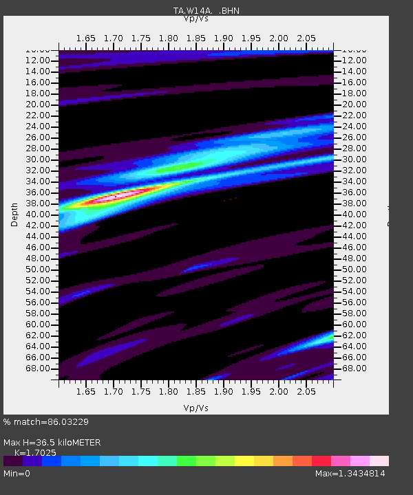
| Estimated Moho Depth: |
36.5 km |
| Estimated Crust Vp/Vs: |
1.70 |
| Assumed Crust Vp: |
6.276 km/s |
| Estimated Crust Vs: |
3.686 km/s |
| Estimated Crust Poisson's Ratio: |
0.24 |
|
| Radial Match: |
86.03229 % |
| Radial Bump: |
308 |
| Transverse Match: |
76.37305 % |
| Transverse Bump: |
400 |
| SOD ConfigId: |
2665 |
| Insert Time: |
2010-03-06 22:49:38.759 +0000 |
| GWidth: |
2.5 |
| Max Bumps: |
400 |
| Tol: |
0.001 |
|

Signal To Noise
| Channel | StoN | STA | LTA |
| TA:W14A: :BHN:20060929T13:17:02.500017Z | 2.5767672 | 9.3069424E-8 | 3.6118678E-8 |
| TA:W14A: :BHE:20060929T13:17:02.500017Z | 5.653419 | 2.8166866E-7 | 4.9822713E-8 |
| TA:W14A: :BHZ:20060929T13:17:02.500017Z | 8.763727 | 5.886366E-7 | 6.7167385E-8 |
| Arrivals |
| Ps | 4.3 SECOND |
| PpPs | 15 SECOND |
| PsPs/PpSs | 19 SECOND |


