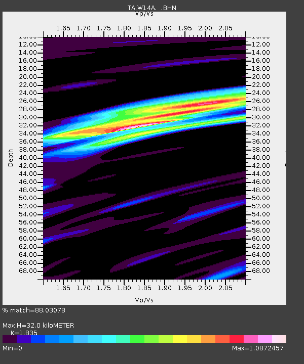
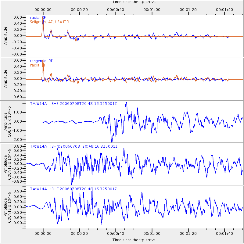
W14A Seligman, AZ, USA - Earthquake Result Viewer

Earthquake location: Andreanof Islands, Aleutian Is.
Earthquake latitude/longitude: 51.2/-179.3
Earthquake time(UTC): 2006/07/08 (189) 20:40:00 GMT
Earthquake Depth: 22 km
Earthquake Magnitude: 6.2 MB, 6.4 MS, 6.6 MW, 6.6 MW
Earthquake Catalog/Contributor: WHDF/NEIC
Network: TA USArray Transportable Network (new EarthScope stations)
Station: W14A Seligman, AZ, USA
Lat/Lon: 35.21 N/113.08 W
Elevation: 1756 m
Distance: 49.2 deg
Az: 82.065 deg
Baz: 310.468 deg
Ray Param: 0.06884275
Estimated Moho Depth: 32.0 km
Estimated Crust Vp/Vs: 1.84
Assumed Crust Vp: 6.276 km/s
Estimated Crust Vs: 3.42 km/s
Estimated Crust Poisson's Ratio: 0.29
Radial Match: 88.03078 %
Radial Bump: 400
Transverse Match: 72.21533 %
Transverse Bump: 400
SOD ConfigId: 2665
Insert Time: 2010-03-06 22:49:56.522 +0000
GWidth: 2.5
Max Bumps: 400
Tol: 0.001

Signal To Noise

ChannelStoNSTALTA
TA:W14A: :BHN:20060708T20:48:16.325001Z2.4689761.504787E-76.094781E-8
TA:W14A: :BHE:20060708T20:48:16.325001Z2.64907381.6913371E-76.384635E-8
TA:W14A: :BHZ:20060708T20:48:16.325001Z4.2974363.2250617E-77.5046174E-8
Arrivals
Ps4.5 SECOND
PpPs14 SECOND
PsPs/PpSs18 SECOND