You are here: Home > Network List > US - United States National Seismic Network Stations List
> Station MIAR Mount Ida, Arkansas, USA > Earthquake Result Viewer
MIAR Mount Ida, Arkansas, USA - Earthquake Result Viewer
| Earthquake location: |
Chile-Argentina Border Region |
| Earthquake latitude/longitude: |
-35.1/-71.0 |
| Earthquake time(UTC): |
2016/11/04 (309) 16:20:43 GMT |
| Earthquake Depth: |
91 km |
| Earthquake Magnitude: |
6.4 MWP, 6.4 MWW |
| Earthquake Catalog/Contributor: |
NEIC PDE/NEIC COMCAT |
|
| Network: |
US United States National Seismic Network |
| Station: |
MIAR Mount Ida, Arkansas, USA |
| Lat/Lon: |
34.55 N/93.58 W |
| Elevation: |
207 m |
|
| Distance: |
72.4 deg |
| Az: |
340.582 deg |
| Baz: |
160.717 deg |
| Ray Param: |
0.05344936 |
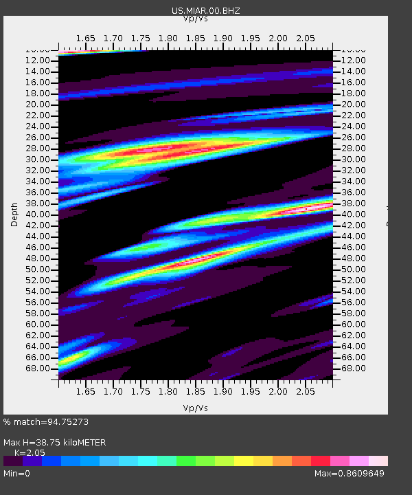
| Estimated Moho Depth: |
38.75 km |
| Estimated Crust Vp/Vs: |
2.05 |
| Assumed Crust Vp: |
6.498 km/s |
| Estimated Crust Vs: |
3.17 km/s |
| Estimated Crust Poisson's Ratio: |
0.34 |
|
| Radial Match: |
94.75273 % |
| Radial Bump: |
397 |
| Transverse Match: |
85.17175 % |
| Transverse Bump: |
400 |
| SOD ConfigId: |
1815711 |
| Insert Time: |
2016-11-18 16:29:02.670 +0000 |
| GWidth: |
2.5 |
| Max Bumps: |
400 |
| Tol: |
0.001 |
|

Signal To Noise
| Channel | StoN | STA | LTA |
| US:MIAR:00:BHZ:20161104T16:31:29.57501Z | 14.805619 | 2.3465534E-6 | 1.5849072E-7 |
| US:MIAR:00:BH1:20161104T16:31:29.57501Z | 10.007211 | 1.0011476E-6 | 1.0004261E-7 |
| US:MIAR:00:BH2:20161104T16:31:29.57501Z | 2.966086 | 1.7993501E-7 | 6.066413E-8 |
| Arrivals |
| Ps | 6.5 SECOND |
| PpPs | 18 SECOND |
| PsPs/PpSs | 24 SECOND |


