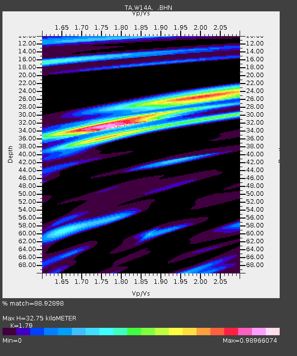
W14A Seligman, AZ, USA - Earthquake Result Viewer

Earthquake location: Rat Islands, Aleutian Islands
Earthquake latitude/longitude: 52.2/176.2
Earthquake time(UTC): 2006/06/27 (178) 02:39:35 GMT
Earthquake Depth: 34 km
Earthquake Magnitude: 5.6 MB, 6.0 MS, 6.2 MW, 6.2 MW
Earthquake Catalog/Contributor: WHDF/NEIC
Network: TA USArray Transportable Network (new EarthScope stations)
Station: W14A Seligman, AZ, USA
Lat/Lon: 35.21 N/113.08 W
Elevation: 1756 m
Distance: 51.8 deg
Az: 79.712 deg
Baz: 312.313 deg
Ray Param: 0.06712614
Estimated Moho Depth: 32.75 km
Estimated Crust Vp/Vs: 1.79
Assumed Crust Vp: 6.276 km/s
Estimated Crust Vs: 3.506 km/s
Estimated Crust Poisson's Ratio: 0.27
Radial Match: 88.92898 %
Radial Bump: 313
Transverse Match: 73.932434 %
Transverse Bump: 400
SOD ConfigId: 2665
Insert Time: 2010-03-06 22:50:01.065 +0000
GWidth: 2.5
Max Bumps: 400
Tol: 0.001

Signal To Noise

ChannelStoNSTALTA
TA:W14A: :BHN:20060627T02:48:09.025005Z3.0540541.4445952E-74.7300905E-8
TA:W14A: :BHE:20060627T02:48:09.025005Z2.54797391.2789026E-75.0192924E-8
TA:W14A: :BHZ:20060627T02:48:09.025005Z10.379773.9634986E-73.818484E-8
Arrivals
Ps4.3 SECOND
PpPs14 SECOND
PsPs/PpSs18 SECOND