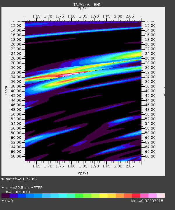
W14A Seligman, AZ, USA - Earthquake Result Viewer
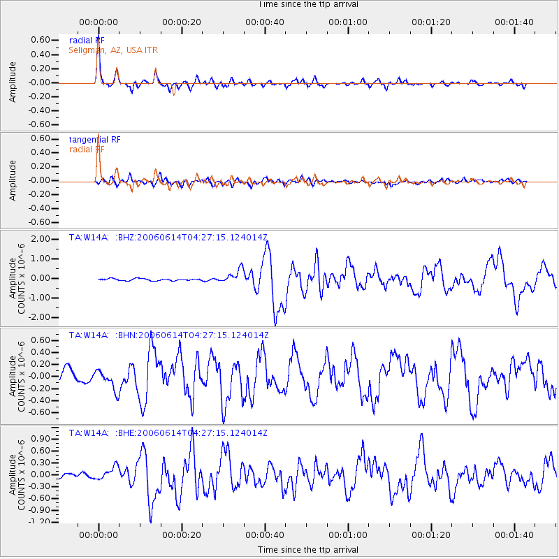
Earthquake location: Rat Islands, Aleutian Islands
Earthquake latitude/longitude: 51.8/177.1
Earthquake time(UTC): 2006/06/14 (165) 04:18:42 GMT
Earthquake Depth: 14 km
Earthquake Magnitude: 5.9 MB, 6.4 MS, 6.4 MW, 6.4 MW
Earthquake Catalog/Contributor: WHDF/NEIC
Network: TA USArray Transportable Network (new EarthScope stations)
Station: W14A Seligman, AZ, USA
Lat/Lon: 35.21 N/113.08 W
Elevation: 1756 m
Distance: 51.3 deg
Az: 79.986 deg
Baz: 311.617 deg
Ray Param: 0.0674853
Estimated Moho Depth: 32.5 km
Estimated Crust Vp/Vs: 1.81
Assumed Crust Vp: 6.276 km/s
Estimated Crust Vs: 3.477 km/s
Estimated Crust Poisson's Ratio: 0.28
Radial Match: 91.77097 %
Radial Bump: 291
Transverse Match: 78.21143 %
Transverse Bump: 400
SOD ConfigId: 5745
Insert Time: 2010-03-06 22:50:03.233 +0000
GWidth: 2.5
Max Bumps: 400
Tol: 0.001

Signal To Noise

ChannelStoNSTALTA
TA:W14A: :BHN:20060614T04:27:15.124014Z1.92639411.7233903E-78.946198E-8
TA:W14A: :BHE:20060614T04:27:15.124014Z1.87531151.7427888E-79.29333E-8
TA:W14A: :BHZ:20060614T04:27:15.124014Z7.3482733.6029374E-74.903108E-8
Arrivals
Ps4.4 SECOND
PpPs14 SECOND
PsPs/PpSs18 SECOND