You are here: Home > Network List > TA - USArray Transportable Network (new EarthScope stations) Stations List
> Station W14A Seligman, AZ, USA > Earthquake Result Viewer
W14A Seligman, AZ, USA - Earthquake Result Viewer
| Earthquake location: |
Panama-Costa Rica Border Region |
| Earthquake latitude/longitude: |
8.2/-82.9 |
| Earthquake time(UTC): |
2006/05/01 (121) 07:47:59 GMT |
| Earthquake Depth: |
13 km |
| Earthquake Magnitude: |
5.1 MB, 5.6 MS, 5.9 MW, 5.9 MW |
| Earthquake Catalog/Contributor: |
WHDF/NEIC |
|
| Network: |
TA USArray Transportable Network (new EarthScope stations) |
| Station: |
W14A Seligman, AZ, USA |
| Lat/Lon: |
35.21 N/113.08 W |
| Elevation: |
1756 m |
|
| Distance: |
38.6 deg |
| Az: |
318.674 deg |
| Baz: |
127.025 deg |
| Ray Param: |
0.07546493 |
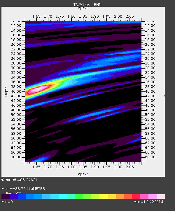
| Estimated Moho Depth: |
38.75 km |
| Estimated Crust Vp/Vs: |
1.65 |
| Assumed Crust Vp: |
6.276 km/s |
| Estimated Crust Vs: |
3.792 km/s |
| Estimated Crust Poisson's Ratio: |
0.21 |
|
| Radial Match: |
86.24631 % |
| Radial Bump: |
244 |
| Transverse Match: |
42.433853 % |
| Transverse Bump: |
400 |
| SOD ConfigId: |
2669 |
| Insert Time: |
2010-03-06 22:50:12.564 +0000 |
| GWidth: |
2.5 |
| Max Bumps: |
400 |
| Tol: |
0.001 |
|

Signal To Noise
| Channel | StoN | STA | LTA |
| TA:W14A: :BHN:20060501T07:54:51.65001Z | 5.6132107 | 3.458084E-7 | 6.1606166E-8 |
| TA:W14A: :BHE:20060501T07:54:51.65001Z | 2.2285755 | 2.8204278E-7 | 1.2655742E-7 |
| TA:W14A: :BHZ:20060501T07:54:51.65001Z | 8.092801 | 6.899907E-7 | 8.525981E-8 |
| Arrivals |
| Ps | 4.4 SECOND |
| PpPs | 15 SECOND |
| PsPs/PpSs | 20 SECOND |


