You are here: Home > Network List > TA - USArray Transportable Network (new EarthScope stations) Stations List
> Station W14A Seligman, AZ, USA > Earthquake Result Viewer
W14A Seligman, AZ, USA - Earthquake Result Viewer
| Earthquake location: |
Eastern Siberia, Russia |
| Earthquake latitude/longitude: |
60.5/165.8 |
| Earthquake time(UTC): |
2006/04/21 (111) 04:32:43 GMT |
| Earthquake Depth: |
9.0 km |
| Earthquake Magnitude: |
6.3 MB, 5.6 MS, 6.1 MW, 6.1 ME |
| Earthquake Catalog/Contributor: |
WHDF/NEIC |
|
| Network: |
TA USArray Transportable Network (new EarthScope stations) |
| Station: |
W14A Seligman, AZ, USA |
| Lat/Lon: |
35.21 N/113.08 W |
| Elevation: |
1756 m |
|
| Distance: |
55.8 deg |
| Az: |
77.877 deg |
| Baz: |
323.81 deg |
| Ray Param: |
0.064536616 |
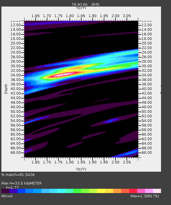
| Estimated Moho Depth: |
33.5 km |
| Estimated Crust Vp/Vs: |
1.77 |
| Assumed Crust Vp: |
6.276 km/s |
| Estimated Crust Vs: |
3.546 km/s |
| Estimated Crust Poisson's Ratio: |
0.27 |
|
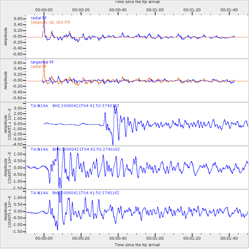
| Radial Match: |
91.5426 % |
| Radial Bump: |
353 |
| Transverse Match: |
81.67059 % |
| Transverse Bump: |
400 |
| SOD ConfigId: |
2669 |
| Insert Time: |
2010-03-06 22:50:19.063 +0000 |
| GWidth: |
2.5 |
| Max Bumps: |
400 |
| Tol: |
0.001 |
|
Signal To Noise
| Channel | StoN | STA | LTA |
| TA:W14A: :BHN:20060421T04:41:50.374016Z | 3.7386556 | 3.6773199E-7 | 9.835942E-8 |
| TA:W14A: :BHE:20060421T04:41:50.374016Z | 3.3459122 | 2.7777617E-7 | 8.3019565E-8 |
| TA:W14A: :BHZ:20060421T04:41:50.374016Z | 6.6172442 | 7.39877E-7 | 1.11810444E-7 |
| Arrivals |
| Ps | 4.3 SECOND |
| PpPs | 14 SECOND |
| PsPs/PpSs | 18 SECOND |


