You are here: Home > Network List > TA - USArray Transportable Network (new EarthScope stations) Stations List
> Station W14A Seligman, AZ, USA > Earthquake Result Viewer
W14A Seligman, AZ, USA - Earthquake Result Viewer
| Earthquake location: |
Kermadec Islands Region |
| Earthquake latitude/longitude: |
-29.6/-176.8 |
| Earthquake time(UTC): |
2006/03/31 (090) 13:21:00 GMT |
| Earthquake Depth: |
17 km |
| Earthquake Magnitude: |
5.9 MB, 6.7 MS, 6.5 MW, 6.5 MW |
| Earthquake Catalog/Contributor: |
WHDF/NEIC |
|
| Network: |
TA USArray Transportable Network (new EarthScope stations) |
| Station: |
W14A Seligman, AZ, USA |
| Lat/Lon: |
35.21 N/113.08 W |
| Elevation: |
1756 m |
|
| Distance: |
88.1 deg |
| Az: |
47.286 deg |
| Baz: |
231.39 deg |
| Ray Param: |
0.04283203 |
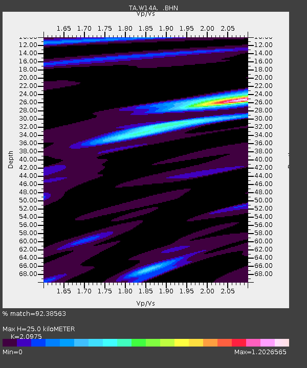
| Estimated Moho Depth: |
25.0 km |
| Estimated Crust Vp/Vs: |
2.10 |
| Assumed Crust Vp: |
6.276 km/s |
| Estimated Crust Vs: |
2.992 km/s |
| Estimated Crust Poisson's Ratio: |
0.35 |
|
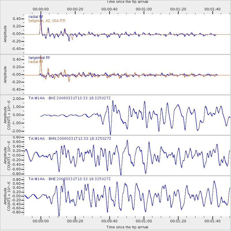
| Radial Match: |
92.38563 % |
| Radial Bump: |
283 |
| Transverse Match: |
72.699 % |
| Transverse Bump: |
400 |
| SOD ConfigId: |
132717 |
| Insert Time: |
2010-03-06 22:50:25.249 +0000 |
| GWidth: |
2.5 |
| Max Bumps: |
400 |
| Tol: |
0.001 |
|
Signal To Noise
| Channel | StoN | STA | LTA |
| TA:W14A: :BHN:20060331T13:33:18.325027Z | 0.28198892 | 3.6723645E-8 | 1.3023082E-7 |
| TA:W14A: :BHE:20060331T13:33:18.325027Z | 1.2500938 | 6.339616E-8 | 5.071312E-8 |
| TA:W14A: :BHZ:20060331T13:33:18.325027Z | 2.1173277 | 1.358547E-7 | 6.416329E-8 |
| Arrivals |
| Ps | 4.4 SECOND |
| PpPs | 12 SECOND |
| PsPs/PpSs | 17 SECOND |


