You are here: Home > Network List > N4 - Central and EAstern US Network Stations List
> Station Y57A Sumter, SC, USA > Earthquake Result Viewer
Y57A Sumter, SC, USA - Earthquake Result Viewer
| Earthquake location: |
Andreanof Islands, Aleutian Is. |
| Earthquake latitude/longitude: |
51.4/-178.3 |
| Earthquake time(UTC): |
2019/05/23 (143) 08:45:18 GMT |
| Earthquake Depth: |
28 km |
| Earthquake Magnitude: |
6.1 Mww |
| Earthquake Catalog/Contributor: |
NEIC PDE/us |
|
| Network: |
N4 Central and EAstern US Network |
| Station: |
Y57A Sumter, SC, USA |
| Lat/Lon: |
34.02 N/80.39 W |
| Elevation: |
56 m |
|
| Distance: |
68.8 deg |
| Az: |
61.941 deg |
| Baz: |
318.235 deg |
| Ray Param: |
0.056039862 |
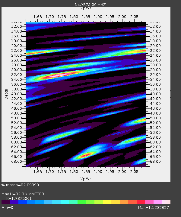
| Estimated Moho Depth: |
32.0 km |
| Estimated Crust Vp/Vs: |
1.74 |
| Assumed Crust Vp: |
6.419 km/s |
| Estimated Crust Vs: |
3.695 km/s |
| Estimated Crust Poisson's Ratio: |
0.25 |
|
| Radial Match: |
82.89399 % |
| Radial Bump: |
400 |
| Transverse Match: |
76.390625 % |
| Transverse Bump: |
400 |
| SOD ConfigId: |
18369291 |
| Insert Time: |
2019-06-06 08:51:42.350 +0000 |
| GWidth: |
2.5 |
| Max Bumps: |
400 |
| Tol: |
0.001 |
|

Signal To Noise
| Channel | StoN | STA | LTA |
| N4:Y57A:00:HHZ:20190523T08:55:49.008975Z | 13.049249 | 2.320193E-6 | 1.778028E-7 |
| N4:Y57A:00:HH1:20190523T08:55:49.008975Z | 4.558883 | 9.546804E-7 | 2.0941103E-7 |
| N4:Y57A:00:HH2:20190523T08:55:49.008975Z | 5.941889 | 1.2388131E-6 | 2.084881E-7 |
| Arrivals |
| Ps | 3.8 SECOND |
| PpPs | 13 SECOND |
| PsPs/PpSs | 17 SECOND |


