You are here: Home > Network List > TS - TERRAscope (Southern California Seismic Network) Stations List
> Station GLA Glamis, California, USA > Earthquake Result Viewer
GLA Glamis, California, USA - Earthquake Result Viewer
*The percent match for this event was below the threshold and hence no stack was calculated.
| Earthquake location: |
New Ireland Region, P.N.G. |
| Earthquake latitude/longitude: |
-5.8/153.6 |
| Earthquake time(UTC): |
1995/08/26 (238) 06:57:17 GMT |
| Earthquake Depth: |
33 km |
| Earthquake Magnitude: |
5.3 MB, 6.1 MS, 6.0 UNKNOWN, 6.1 MW |
| Earthquake Catalog/Contributor: |
WHDF/NEIC |
|
| Network: |
TS TERRAscope (Southern California Seismic Network) |
| Station: |
GLA Glamis, California, USA |
| Lat/Lon: |
33.05 N/114.83 W |
| Elevation: |
627 m |
|
| Distance: |
94.4 deg |
| Az: |
57.356 deg |
| Baz: |
265.988 deg |
| Ray Param: |
$rayparam |
*The percent match for this event was below the threshold and hence was not used in the summary stack. |
|
| Radial Match: |
56.777668 % |
| Radial Bump: |
400 |
| Transverse Match: |
46.76783 % |
| Transverse Bump: |
400 |
| SOD ConfigId: |
4480 |
| Insert Time: |
2010-02-26 14:13:59.862 +0000 |
| GWidth: |
2.5 |
| Max Bumps: |
400 |
| Tol: |
0.001 |
|
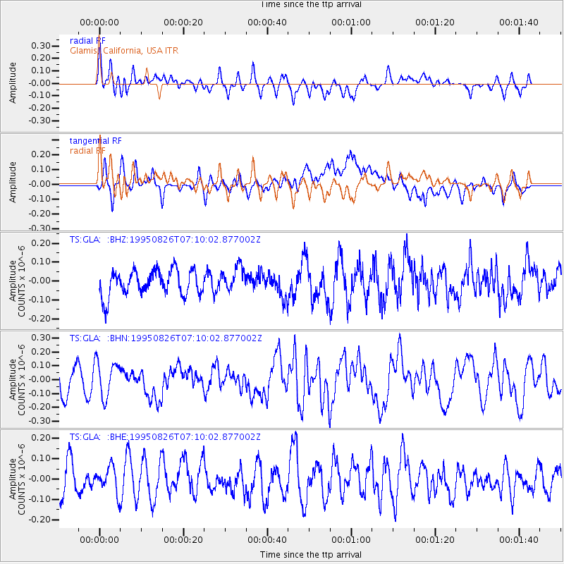
Signal To Noise
| Channel | StoN | STA | LTA |
| TS:GLA: :BHN:19950826T07:10:02.877002Z | 1.2438236 | 1.2686486E-7 | 1.0199586E-7 |
| TS:GLA: :BHE:19950826T07:10:02.877002Z | 0.8081813 | 7.821843E-8 | 9.6783275E-8 |
| TS:GLA: :BHZ:19950826T07:10:02.877002Z | 0.993391 | 6.5600304E-8 | 6.603674E-8 |
| Arrivals |
| Ps | |
| PpPs | |
| PsPs/PpSs | |


