You are here: Home > Network List > UU - University of Utah Regional Network Stations List
> Station NLU North Lily, UT, USA > Earthquake Result Viewer
NLU North Lily, UT, USA - Earthquake Result Viewer
| Earthquake location: |
Chile-Argentina Border Region |
| Earthquake latitude/longitude: |
-35.1/-71.0 |
| Earthquake time(UTC): |
2016/11/04 (309) 16:20:43 GMT |
| Earthquake Depth: |
91 km |
| Earthquake Magnitude: |
6.4 MWP, 6.4 MWW |
| Earthquake Catalog/Contributor: |
NEIC PDE/NEIC COMCAT |
|
| Network: |
UU University of Utah Regional Network |
| Station: |
NLU North Lily, UT, USA |
| Lat/Lon: |
39.95 N/112.07 W |
| Elevation: |
2036 m |
|
| Distance: |
83.7 deg |
| Az: |
329.462 deg |
| Baz: |
147.181 deg |
| Ray Param: |
0.045775596 |
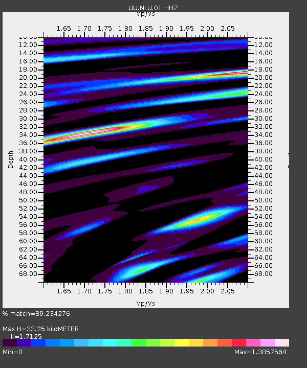
| Estimated Moho Depth: |
33.25 km |
| Estimated Crust Vp/Vs: |
1.71 |
| Assumed Crust Vp: |
6.276 km/s |
| Estimated Crust Vs: |
3.665 km/s |
| Estimated Crust Poisson's Ratio: |
0.24 |
|
| Radial Match: |
89.234276 % |
| Radial Bump: |
400 |
| Transverse Match: |
80.707375 % |
| Transverse Bump: |
400 |
| SOD ConfigId: |
1815711 |
| Insert Time: |
2016-11-18 16:30:15.146 +0000 |
| GWidth: |
2.5 |
| Max Bumps: |
400 |
| Tol: |
0.001 |
|

Signal To Noise
| Channel | StoN | STA | LTA |
| UU:NLU:01:HHZ:20161104T16:32:31.840024Z | 6.9505105 | 4.641833E-8 | 6.678406E-9 |
| UU:NLU:01:HHN:20161104T16:32:31.840024Z | 2.693821 | 1.1074768E-8 | 4.1111745E-9 |
| UU:NLU:01:HHE:20161104T16:32:31.840024Z | 1.0229872 | 7.0005304E-9 | 6.8432233E-9 |
| Arrivals |
| Ps | 3.9 SECOND |
| PpPs | 14 SECOND |
| PsPs/PpSs | 18 SECOND |


