You are here: Home > Network List > US - United States National Seismic Network Stations List
> Station MSO Missoula, Montana, USA > Earthquake Result Viewer
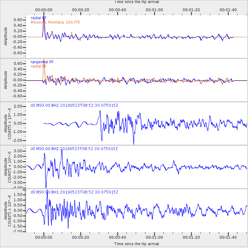
MSO Missoula, Montana, USA - Earthquake Result Viewer
*The percent match for this event was below the threshold and hence no stack was calculated.
| Earthquake location: |
Andreanof Islands, Aleutian Is. |
| Earthquake latitude/longitude: |
51.4/-178.3 |
| Earthquake time(UTC): |
2019/05/23 (143) 08:45:18 GMT |
| Earthquake Depth: |
28 km |
| Earthquake Magnitude: |
6.1 Mww |
| Earthquake Catalog/Contributor: |
NEIC PDE/us |
|
| Network: |
US United States National Seismic Network |
| Station: |
MSO Missoula, Montana, USA |
| Lat/Lon: |
46.83 N/113.94 W |
| Elevation: |
1264 m |
|
| Distance: |
41.2 deg |
| Az: |
70.063 deg |
| Baz: |
300.867 deg |
| Ray Param: |
$rayparam |
*The percent match for this event was below the threshold and hence was not used in the summary stack. |
|
| Radial Match: |
77.967575 % |
| Radial Bump: |
400 |
| Transverse Match: |
76.024254 % |
| Transverse Bump: |
400 |
| SOD ConfigId: |
18369291 |
| Insert Time: |
2019-06-06 08:55:45.059 +0000 |
| GWidth: |
2.5 |
| Max Bumps: |
400 |
| Tol: |
0.001 |
|
Signal To Noise
| Channel | StoN | STA | LTA |
| US:MSO:00:BHZ:20190523T08:52:30.075015Z | 6.166651 | 1.4999187E-6 | 2.432307E-7 |
| US:MSO:00:BH1:20190523T08:52:30.075015Z | 5.502706 | 8.442305E-7 | 1.5342097E-7 |
| US:MSO:00:BH2:20190523T08:52:30.075015Z | 6.561304 | 9.211019E-7 | 1.4038397E-7 |
| Arrivals |
| Ps | |
| PpPs | |
| PsPs/PpSs | |


