You are here: Home > Network List > TS - TERRAscope (Southern California Seismic Network) Stations List
> Station GLA Glamis, California, USA > Earthquake Result Viewer
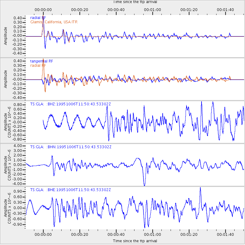
GLA Glamis, California, USA - Earthquake Result Viewer
*The percent match for this event was below the threshold and hence no stack was calculated.
| Earthquake location: |
Tonga Islands |
| Earthquake latitude/longitude: |
-20.0/-175.9 |
| Earthquake time(UTC): |
1995/10/06 (279) 11:39:36 GMT |
| Earthquake Depth: |
209 km |
| Earthquake Magnitude: |
5.7 MB, 6.4 UNKNOWN, 6.3 MW |
| Earthquake Catalog/Contributor: |
WHDF/NEIC |
|
| Network: |
TS TERRAscope (Southern California Seismic Network) |
| Station: |
GLA Glamis, California, USA |
| Lat/Lon: |
33.05 N/114.83 W |
| Elevation: |
627 m |
|
| Distance: |
78.6 deg |
| Az: |
48.583 deg |
| Baz: |
237.099 deg |
| Ray Param: |
$rayparam |
*The percent match for this event was below the threshold and hence was not used in the summary stack. |
|
| Radial Match: |
79.22558 % |
| Radial Bump: |
400 |
| Transverse Match: |
56.65544 % |
| Transverse Bump: |
400 |
| SOD ConfigId: |
4480 |
| Insert Time: |
2010-02-26 14:14:04.305 +0000 |
| GWidth: |
2.5 |
| Max Bumps: |
400 |
| Tol: |
0.001 |
|
Signal To Noise
| Channel | StoN | STA | LTA |
| TS:GLA: :BHN:19951006T11:50:43.53302Z | 2.0886338 | 5.175335E-7 | 2.477857E-7 |
| TS:GLA: :BHE:19951006T11:50:43.53302Z | 0.69916826 | 1.8398808E-7 | 2.631528E-7 |
| TS:GLA: :BHZ:19951006T11:50:43.53302Z | 0.86656255 | 1.8901986E-7 | 2.1812603E-7 |
| Arrivals |
| Ps | |
| PpPs | |
| PsPs/PpSs | |


