You are here: Home > Network List > TS - TERRAscope (Southern California Seismic Network) Stations List
> Station GLA Glamis, California, USA > Earthquake Result Viewer
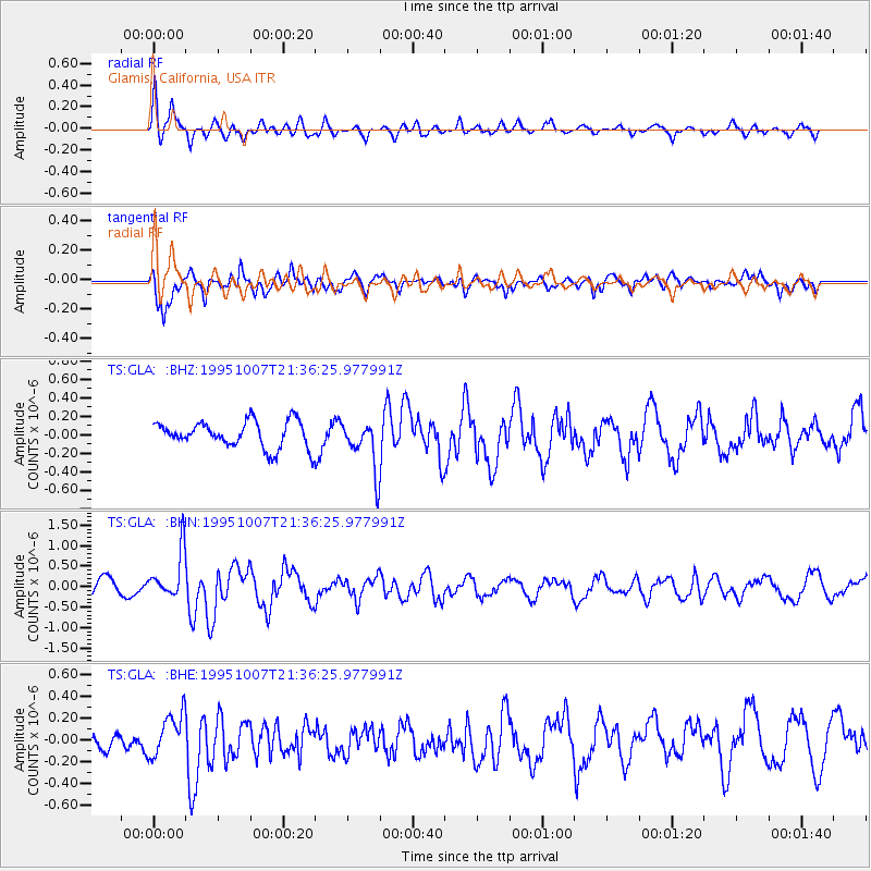
GLA Glamis, California, USA - Earthquake Result Viewer
*The percent match for this event was below the threshold and hence no stack was calculated.
| Earthquake location: |
Peru-Ecuador Border Region |
| Earthquake latitude/longitude: |
-2.8/-77.8 |
| Earthquake time(UTC): |
1995/10/07 (280) 21:28:06 GMT |
| Earthquake Depth: |
33 km |
| Earthquake Magnitude: |
5.8 MB, 5.2 MS, 5.8 UNKNOWN |
| Earthquake Catalog/Contributor: |
WHDF/NEIC |
|
| Network: |
TS TERRAscope (Southern California Seismic Network) |
| Station: |
GLA Glamis, California, USA |
| Lat/Lon: |
33.05 N/114.83 W |
| Elevation: |
627 m |
|
| Distance: |
49.9 deg |
| Az: |
318.67 deg |
| Baz: |
128.242 deg |
| Ray Param: |
$rayparam |
*The percent match for this event was below the threshold and hence was not used in the summary stack. |
|
| Radial Match: |
69.52911 % |
| Radial Bump: |
400 |
| Transverse Match: |
57.38617 % |
| Transverse Bump: |
400 |
| SOD ConfigId: |
4480 |
| Insert Time: |
2010-02-26 14:14:07.098 +0000 |
| GWidth: |
2.5 |
| Max Bumps: |
400 |
| Tol: |
0.001 |
|
Signal To Noise
| Channel | StoN | STA | LTA |
| TS:GLA: :BHN:19951007T21:36:25.977991Z | 2.4087634 | 5.753838E-7 | 2.3887102E-7 |
| TS:GLA: :BHE:19951007T21:36:25.977991Z | 2.8305736 | 1.9093807E-7 | 6.745561E-8 |
| TS:GLA: :BHZ:19951007T21:36:25.977991Z | 1.8932319 | 2.7018527E-7 | 1.4271113E-7 |
| Arrivals |
| Ps | |
| PpPs | |
| PsPs/PpSs | |


