You are here: Home > Network List > TA - USArray Transportable Network (new EarthScope stations) Stations List
> Station L15K Ungalak Mountain, AK, USA > Earthquake Result Viewer
L15K Ungalak Mountain, AK, USA - Earthquake Result Viewer
*The percent match for this event was below the threshold and hence no stack was calculated.
| Earthquake location: |
Southeast Of Loyalty Islands |
| Earthquake latitude/longitude: |
-21.6/169.8 |
| Earthquake time(UTC): |
2019/05/23 (143) 15:02:17 GMT |
| Earthquake Depth: |
10 km |
| Earthquake Magnitude: |
5.7 Mww |
| Earthquake Catalog/Contributor: |
NEIC PDE/us |
|
| Network: |
TA USArray Transportable Network (new EarthScope stations) |
| Station: |
L15K Ungalak Mountain, AK, USA |
| Lat/Lon: |
61.68 N/161.49 W |
| Elevation: |
219 m |
|
| Distance: |
86.1 deg |
| Az: |
13.288 deg |
| Baz: |
206.648 deg |
| Ray Param: |
$rayparam |
*The percent match for this event was below the threshold and hence was not used in the summary stack. |
|
| Radial Match: |
53.08213 % |
| Radial Bump: |
400 |
| Transverse Match: |
49.194374 % |
| Transverse Bump: |
385 |
| SOD ConfigId: |
18369291 |
| Insert Time: |
2019-06-06 15:05:40.160 +0000 |
| GWidth: |
2.5 |
| Max Bumps: |
400 |
| Tol: |
0.001 |
|
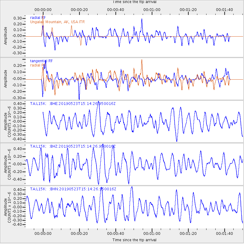
Signal To Noise
| Channel | StoN | STA | LTA |
| TA:L15K: :BHZ:20190523T15:14:26.950016Z | 1.7438996 | 2.6244342E-7 | 1.5049228E-7 |
| TA:L15K: :BHN:20190523T15:14:26.950016Z | 0.63650876 | 1.1016489E-7 | 1.7307677E-7 |
| TA:L15K: :BHE:20190523T15:14:26.950016Z | 2.113859 | 2.5604623E-7 | 1.2112741E-7 |
| Arrivals |
| Ps | |
| PpPs | |
| PsPs/PpSs | |


