You are here: Home > Network List > GS - US Geological Survey Networks Stations List
> Station OK051 E0350 and S34600 Roads, Ralston, OK > Earthquake Result Viewer
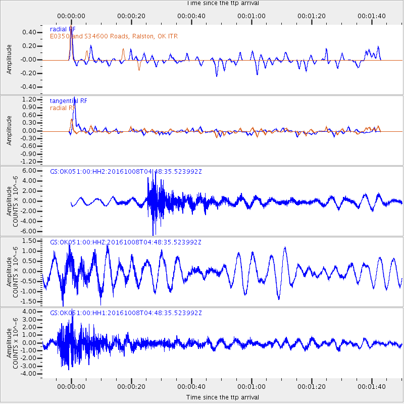
OK051 E0350 and S34600 Roads, Ralston, OK - Earthquake Result Viewer
*The percent match for this event was below the threshold and hence no stack was calculated.
| Earthquake location: |
Southeast Of Easter Island |
| Earthquake latitude/longitude: |
-36.0/-101.0 |
| Earthquake time(UTC): |
2016/10/08 (282) 04:37:41 GMT |
| Earthquake Depth: |
10 km |
| Earthquake Magnitude: |
5.6 MWC, 5.6 MWC |
| Earthquake Catalog/Contributor: |
NEIC PDE/NEIC COMCAT |
|
| Network: |
GS US Geological Survey Networks |
| Station: |
OK051 E0350 and S34600 Roads, Ralston, OK |
| Lat/Lon: |
36.51 N/96.84 W |
| Elevation: |
263 m |
|
| Distance: |
72.3 deg |
| Az: |
3.529 deg |
| Baz: |
183.551 deg |
| Ray Param: |
$rayparam |
*The percent match for this event was below the threshold and hence was not used in the summary stack. |
|
| Radial Match: |
43.137337 % |
| Radial Bump: |
400 |
| Transverse Match: |
81.9418 % |
| Transverse Bump: |
400 |
| SOD ConfigId: |
1815711 |
| Insert Time: |
2016-11-18 23:01:14.485 +0000 |
| GWidth: |
2.5 |
| Max Bumps: |
400 |
| Tol: |
0.001 |
|
Signal To Noise
| Channel | StoN | STA | LTA |
| GS:OK051:00:HHZ:20161008T04:48:35.523992Z | 0.9250834 | 5.122188E-7 | 5.5370015E-7 |
| GS:OK051:00:HH1:20161008T04:48:35.523992Z | 2.7513564 | 1.4865526E-6 | 5.402981E-7 |
| GS:OK051:00:HH2:20161008T04:48:35.523992Z | 3.128096 | 1.5893659E-6 | 5.080937E-7 |
| Arrivals |
| Ps | |
| PpPs | |
| PsPs/PpSs | |


