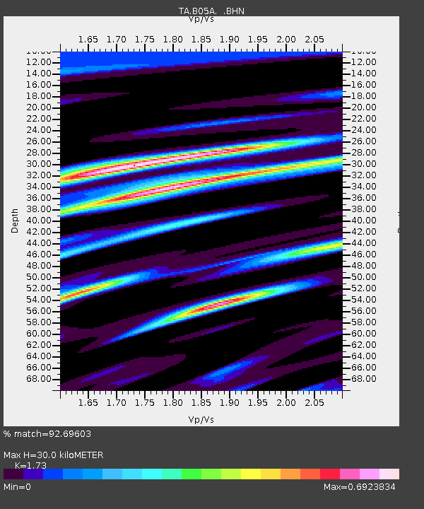
B05A Bryant, WA, USA - Earthquake Result Viewer
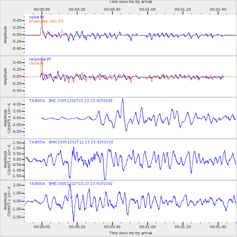
Earthquake location: Near East Coast Of Honshu, Japan
Earthquake latitude/longitude: 38.1/142.1
Earthquake time(UTC): 2005/12/02 (336) 13:13:09 GMT
Earthquake Depth: 29 km
Earthquake Magnitude: 6.1 MB, 6.3 MS, 6.5 MW, 6.4 MW
Earthquake Catalog/Contributor: WHDF/NEIC
Network: TA USArray Transportable Network (new EarthScope stations)
Station: B05A Bryant, WA, USA
Lat/Lon: 48.26 N/122.10 W
Elevation: 154 m
Distance: 66.2 deg
Az: 46.611 deg
Baz: 300.888 deg
Ray Param: 0.057745323
Estimated Moho Depth: 30.0 km
Estimated Crust Vp/Vs: 1.73
Assumed Crust Vp: 6.566 km/s
Estimated Crust Vs: 3.795 km/s
Estimated Crust Poisson's Ratio: 0.25
Radial Match: 92.69603 %
Radial Bump: 400
Transverse Match: 81.85194 %
Transverse Bump: 400
SOD ConfigId: 2422
Insert Time: 2010-03-06 22:54:46.337 +0000
GWidth: 2.5
Max Bumps: 400
Tol: 0.001

Signal To Noise

ChannelStoNSTALTA
TA:B05A: :BHN:20051202T13:23:23.425029Z1.941842.700248E-71.3905616E-7
TA:B05A: :BHE:20051202T13:23:23.425029Z3.30062635.4010616E-71.6363747E-7
TA:B05A: :BHZ:20051202T13:23:23.425029Z6.43990561.1926593E-61.8519825E-7
Arrivals
Ps3.5 SECOND
PpPs12 SECOND
PsPs/PpSs15 SECOND