You are here: Home > Network List > GT - Global Telemetered Seismograph Network (USAF/USGS) Stations List
> Station LPAZ La Paz , Bolivia > Earthquake Result Viewer
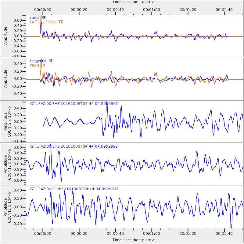
LPAZ La Paz , Bolivia - Earthquake Result Viewer
*The percent match for this event was below the threshold and hence no stack was calculated.
| Earthquake location: |
Southeast Of Easter Island |
| Earthquake latitude/longitude: |
-36.0/-101.0 |
| Earthquake time(UTC): |
2016/10/08 (282) 04:37:41 GMT |
| Earthquake Depth: |
10 km |
| Earthquake Magnitude: |
5.6 MWC, 5.6 MWC |
| Earthquake Catalog/Contributor: |
NEIC PDE/NEIC COMCAT |
|
| Network: |
GT Global Telemetered Seismograph Network (USAF/USGS) |
| Station: |
LPAZ La Paz , Bolivia |
| Lat/Lon: |
16.17 S/68.08 W |
| Elevation: |
4817 m |
|
| Distance: |
35.3 deg |
| Az: |
64.612 deg |
| Baz: |
229.65 deg |
| Ray Param: |
$rayparam |
*The percent match for this event was below the threshold and hence was not used in the summary stack. |
|
| Radial Match: |
62.293438 % |
| Radial Bump: |
400 |
| Transverse Match: |
41.49758 % |
| Transverse Bump: |
388 |
| SOD ConfigId: |
1815711 |
| Insert Time: |
2016-11-18 23:01:18.338 +0000 |
| GWidth: |
2.5 |
| Max Bumps: |
400 |
| Tol: |
0.001 |
|
Signal To Noise
| Channel | StoN | STA | LTA |
| GT:LPAZ:00:BHZ:20161008T04:44:04.899999Z | 4.6125617 | 4.5978587E-7 | 9.9681245E-8 |
| GT:LPAZ:00:BHN:20161008T04:44:04.899999Z | 1.703026 | 1.4324343E-7 | 8.4111115E-8 |
| GT:LPAZ:00:BHE:20161008T04:44:04.899999Z | 3.7930443 | 2.68325E-7 | 7.074133E-8 |
| Arrivals |
| Ps | |
| PpPs | |
| PsPs/PpSs | |


