You are here: Home > Network List > TA - USArray Transportable Network (new EarthScope stations) Stations List
> Station B05A Bryant, WA, USA > Earthquake Result Viewer
B05A Bryant, WA, USA - Earthquake Result Viewer
| Earthquake location: |
Northern Chile |
| Earthquake latitude/longitude: |
-22.2/-69.9 |
| Earthquake time(UTC): |
2007/11/14 (318) 15:40:50 GMT |
| Earthquake Depth: |
40 km |
| Earthquake Magnitude: |
6.7 MB, 7.4 MS, 7.7 MW, 7.4 ME |
| Earthquake Catalog/Contributor: |
WHDF/NEIC |
|
| Network: |
TA USArray Transportable Network (new EarthScope stations) |
| Station: |
B05A Bryant, WA, USA |
| Lat/Lon: |
48.26 N/122.10 W |
| Elevation: |
154 m |
|
| Distance: |
84.3 deg |
| Az: |
327.952 deg |
| Baz: |
132.631 deg |
| Ray Param: |
0.045520708 |
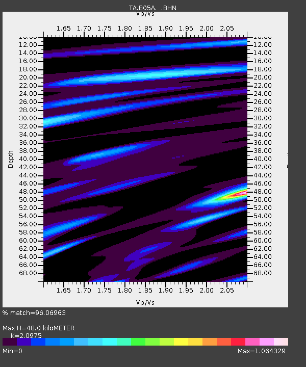
| Estimated Moho Depth: |
48.0 km |
| Estimated Crust Vp/Vs: |
2.10 |
| Assumed Crust Vp: |
6.566 km/s |
| Estimated Crust Vs: |
3.13 km/s |
| Estimated Crust Poisson's Ratio: |
0.35 |
|
| Radial Match: |
96.06963 % |
| Radial Bump: |
400 |
| Transverse Match: |
87.221344 % |
| Transverse Bump: |
400 |
| SOD ConfigId: |
2564 |
| Insert Time: |
2010-03-06 22:54:54.043 +0000 |
| GWidth: |
2.5 |
| Max Bumps: |
400 |
| Tol: |
0.001 |
|

Signal To Noise
| Channel | StoN | STA | LTA |
| TA:B05A: :BHN:20071114T15:52:47.074006Z | 4.7738795 | 9.3852765E-7 | 1.9659642E-7 |
| TA:B05A: :BHE:20071114T15:52:47.074006Z | 7.3973804 | 1.4372955E-6 | 1.942979E-7 |
| TA:B05A: :BHZ:20071114T15:52:47.074006Z | 15.883282 | 4.424832E-6 | 2.7858422E-7 |
| Arrivals |
| Ps | 8.2 SECOND |
| PpPs | 22 SECOND |
| PsPs/PpSs | 30 SECOND |


