You are here: Home > Network List > TA - USArray Transportable Network (new EarthScope stations) Stations List
> Station B05A Bryant, WA, USA > Earthquake Result Viewer
B05A Bryant, WA, USA - Earthquake Result Viewer
| Earthquake location: |
Near West Coast Of Colombia |
| Earthquake latitude/longitude: |
3.0/-78.0 |
| Earthquake time(UTC): |
2007/09/10 (253) 01:49:14 GMT |
| Earthquake Depth: |
31 km |
| Earthquake Magnitude: |
6.1 MB, 6.7 MS, 6.8 MW |
| Earthquake Catalog/Contributor: |
WHDF/NEIC |
|
| Network: |
TA USArray Transportable Network (new EarthScope stations) |
| Station: |
B05A Bryant, WA, USA |
| Lat/Lon: |
48.26 N/122.10 W |
| Elevation: |
154 m |
|
| Distance: |
58.8 deg |
| Az: |
327.066 deg |
| Baz: |
125.652 deg |
| Ray Param: |
0.06252969 |
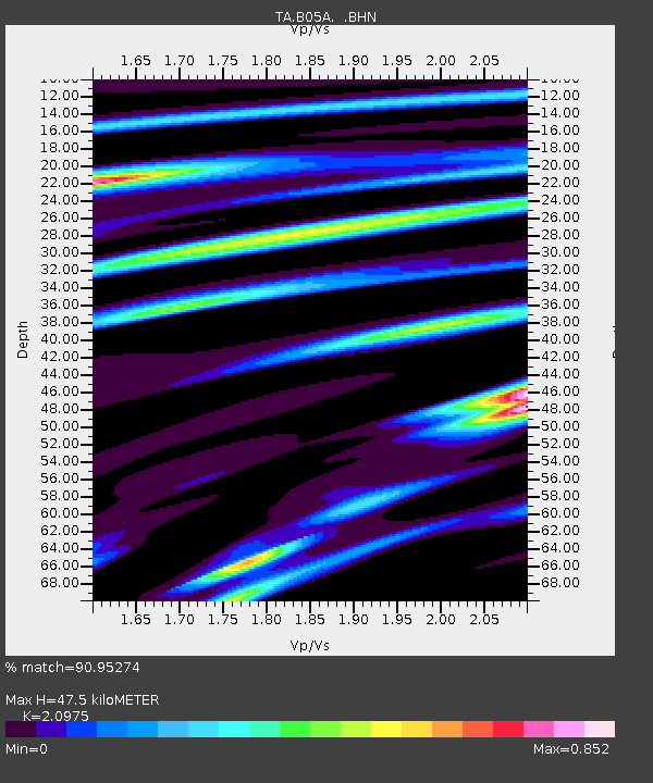
| Estimated Moho Depth: |
47.5 km |
| Estimated Crust Vp/Vs: |
2.10 |
| Assumed Crust Vp: |
6.566 km/s |
| Estimated Crust Vs: |
3.13 km/s |
| Estimated Crust Poisson's Ratio: |
0.35 |
|
| Radial Match: |
90.95274 % |
| Radial Bump: |
400 |
| Transverse Match: |
87.574585 % |
| Transverse Bump: |
400 |
| SOD ConfigId: |
2564 |
| Insert Time: |
2010-03-06 22:55:02.638 +0000 |
| GWidth: |
2.5 |
| Max Bumps: |
400 |
| Tol: |
0.001 |
|

Signal To Noise
| Channel | StoN | STA | LTA |
| TA:B05A: :BHN:20070910T01:58:39.024016Z | 2.917297 | 4.0745036E-7 | 1.396671E-7 |
| TA:B05A: :BHE:20070910T01:58:39.024016Z | 5.209261 | 5.4745846E-7 | 1.050933E-7 |
| TA:B05A: :BHZ:20070910T01:58:39.024016Z | 7.2161694 | 1.3081467E-6 | 1.8127993E-7 |
| Arrivals |
| Ps | 8.3 SECOND |
| PpPs | 21 SECOND |
| PsPs/PpSs | 30 SECOND |


