You are here: Home > Network List > AK - Alaska Regional Network Stations List
> Station PWL Port Wells, AK, USA > Earthquake Result Viewer
PWL Port Wells, AK, USA - Earthquake Result Viewer
| Earthquake location: |
Northern Peru |
| Earthquake latitude/longitude: |
-5.9/-75.3 |
| Earthquake time(UTC): |
2019/05/26 (146) 07:41:13 GMT |
| Earthquake Depth: |
105 km |
| Earthquake Magnitude: |
7.5 Mi |
| Earthquake Catalog/Contributor: |
NEIC PDE/at |
|
| Network: |
AK Alaska Regional Network |
| Station: |
PWL Port Wells, AK, USA |
| Lat/Lon: |
60.86 N/148.33 W |
| Elevation: |
555 m |
|
| Distance: |
87.0 deg |
| Az: |
332.043 deg |
| Baz: |
107.672 deg |
| Ray Param: |
0.04344866 |
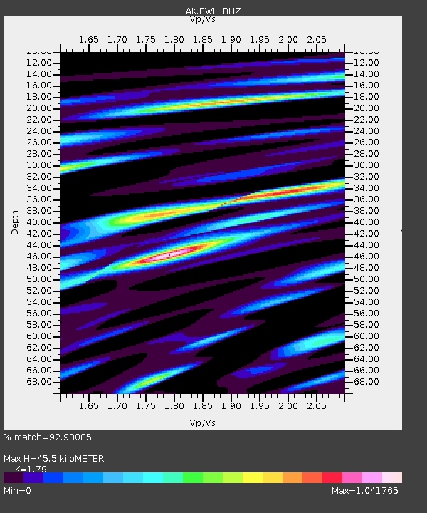
| Estimated Moho Depth: |
45.5 km |
| Estimated Crust Vp/Vs: |
1.79 |
| Assumed Crust Vp: |
6.566 km/s |
| Estimated Crust Vs: |
3.668 km/s |
| Estimated Crust Poisson's Ratio: |
0.27 |
|
| Radial Match: |
92.93085 % |
| Radial Bump: |
400 |
| Transverse Match: |
87.534996 % |
| Transverse Bump: |
400 |
| SOD ConfigId: |
18369291 |
| Insert Time: |
2019-06-09 07:42:11.387 +0000 |
| GWidth: |
2.5 |
| Max Bumps: |
400 |
| Tol: |
0.001 |
|

Signal To Noise
| Channel | StoN | STA | LTA |
| AK:PWL: :BHZ:20190526T07:53:15.16803Z | 28.16186 | 9.515191E-6 | 3.378751E-7 |
| AK:PWL: :BHN:20190526T07:53:15.16803Z | 6.7551775 | 1.9238532E-6 | 2.8479687E-7 |
| AK:PWL: :BHE:20190526T07:53:15.16803Z | 9.004277 | 2.9772466E-6 | 3.3064802E-7 |
| Arrivals |
| Ps | 5.6 SECOND |
| PpPs | 19 SECOND |
| PsPs/PpSs | 24 SECOND |


