You are here: Home > Network List > TS - TERRAscope (Southern California Seismic Network) Stations List
> Station GLA Glamis, California, USA > Earthquake Result Viewer
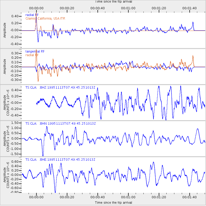
GLA Glamis, California, USA - Earthquake Result Viewer
*The percent match for this event was below the threshold and hence no stack was calculated.
| Earthquake location: |
Tonga Islands |
| Earthquake latitude/longitude: |
-15.1/-173.5 |
| Earthquake time(UTC): |
1995/11/13 (317) 07:38:45 GMT |
| Earthquake Depth: |
33 km |
| Earthquake Magnitude: |
5.7 MB, 5.9 MS, 6.1 UNKNOWN, 6.0 MW |
| Earthquake Catalog/Contributor: |
WHDF/NEIC |
|
| Network: |
TS TERRAscope (Southern California Seismic Network) |
| Station: |
GLA Glamis, California, USA |
| Lat/Lon: |
33.05 N/114.83 W |
| Elevation: |
627 m |
|
| Distance: |
73.7 deg |
| Az: |
48.382 deg |
| Baz: |
239.295 deg |
| Ray Param: |
$rayparam |
*The percent match for this event was below the threshold and hence was not used in the summary stack. |
|
| Radial Match: |
65.72207 % |
| Radial Bump: |
400 |
| Transverse Match: |
48.74292 % |
| Transverse Bump: |
400 |
| SOD ConfigId: |
4480 |
| Insert Time: |
2010-02-26 14:14:12.896 +0000 |
| GWidth: |
2.5 |
| Max Bumps: |
400 |
| Tol: |
0.001 |
|
Signal To Noise
| Channel | StoN | STA | LTA |
| TS:GLA: :BHN:19951113T07:49:45.251013Z | 3.7727804 | 6.0305194E-7 | 1.5984284E-7 |
| TS:GLA: :BHE:19951113T07:49:45.251013Z | 1.0143708 | 1.9058538E-7 | 1.8788532E-7 |
| TS:GLA: :BHZ:19951113T07:49:45.251013Z | 2.593554 | 2.5625695E-7 | 9.880533E-8 |
| Arrivals |
| Ps | |
| PpPs | |
| PsPs/PpSs | |


