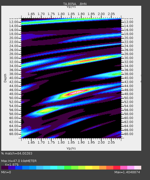
B05A Bryant, WA, USA - Earthquake Result Viewer

Earthquake location: Andreanof Islands, Aleutian Is.
Earthquake latitude/longitude: 51.3/-180.0
Earthquake time(UTC): 2007/08/02 (214) 03:21:42 GMT
Earthquake Depth: 21 km
Earthquake Magnitude: 6.3 MB, 6.6 MS, 6.7 MW, 6.6 MW
Earthquake Catalog/Contributor: WHDF/NEIC
Network: TA USArray Transportable Network (new EarthScope stations)
Station: B05A Bryant, WA, USA
Lat/Lon: 48.26 N/122.10 W
Elevation: 154 m
Distance: 36.7 deg
Az: 71.403 deg
Baz: 297.081 deg
Ray Param: 0.076532856
Estimated Moho Depth: 47.0 km
Estimated Crust Vp/Vs: 1.88
Assumed Crust Vp: 6.566 km/s
Estimated Crust Vs: 3.502 km/s
Estimated Crust Poisson's Ratio: 0.30
Radial Match: 84.00283 %
Radial Bump: 400
Transverse Match: 72.041504 %
Transverse Bump: 400
SOD ConfigId: 2564
Insert Time: 2010-03-06 22:55:15.004 +0000
GWidth: 2.5
Max Bumps: 400
Tol: 0.001

Signal To Noise

ChannelStoNSTALTA
TA:B05A: :BHN:20070802T03:28:17.175011Z2.72713851.3820807E-65.067878E-7
TA:B05A: :BHE:20070802T03:28:17.175011Z4.23180771.5873693E-63.7510432E-7
TA:B05A: :BHZ:20070802T03:28:17.175011Z3.39841443.1049622E-69.1365024E-7
Arrivals
Ps6.7 SECOND
PpPs19 SECOND
PsPs/PpSs26 SECOND