You are here: Home > Network List > TA - USArray Transportable Network (new EarthScope stations) Stations List
> Station B05A Bryant, WA, USA > Earthquake Result Viewer
B05A Bryant, WA, USA - Earthquake Result Viewer
| Earthquake location: |
Vanuatu Islands |
| Earthquake latitude/longitude: |
-15.6/167.7 |
| Earthquake time(UTC): |
2007/08/01 (213) 17:08:51 GMT |
| Earthquake Depth: |
120 km |
| Earthquake Magnitude: |
6.2 MB, 7.2 MW, 7.2 MW |
| Earthquake Catalog/Contributor: |
WHDF/NEIC |
|
| Network: |
TA USArray Transportable Network (new EarthScope stations) |
| Station: |
B05A Bryant, WA, USA |
| Lat/Lon: |
48.26 N/122.10 W |
| Elevation: |
154 m |
|
| Distance: |
88.9 deg |
| Az: |
38.968 deg |
| Baz: |
245.092 deg |
| Ray Param: |
0.04198778 |
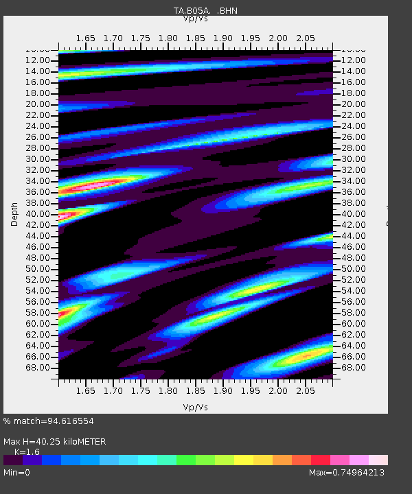
| Estimated Moho Depth: |
40.25 km |
| Estimated Crust Vp/Vs: |
1.60 |
| Assumed Crust Vp: |
6.566 km/s |
| Estimated Crust Vs: |
4.104 km/s |
| Estimated Crust Poisson's Ratio: |
0.18 |
|
| Radial Match: |
94.616554 % |
| Radial Bump: |
400 |
| Transverse Match: |
79.78059 % |
| Transverse Bump: |
400 |
| SOD ConfigId: |
2564 |
| Insert Time: |
2010-03-06 22:55:18.050 +0000 |
| GWidth: |
2.5 |
| Max Bumps: |
400 |
| Tol: |
0.001 |
|

Signal To Noise
| Channel | StoN | STA | LTA |
| TA:B05A: :BHN:20070801T17:21:01.074011Z | 1.5491452 | 9.4899015E-8 | 6.125895E-8 |
| TA:B05A: :BHE:20070801T17:21:01.074011Z | 3.2734547 | 1.9504667E-7 | 5.958435E-8 |
| TA:B05A: :BHZ:20070801T17:21:01.074011Z | 9.150033 | 8.7427406E-7 | 9.554874E-8 |
| Arrivals |
| Ps | 3.8 SECOND |
| PpPs | 16 SECOND |
| PsPs/PpSs | 19 SECOND |


